You are here: Home > Network List > II - Global Seismograph Network (GSN - IRIS/IDA) Stations List
> Station LVZ Lovozero, Russia > Earthquake Result Viewer
LVZ Lovozero, Russia - Earthquake Result Viewer

| Earthquake location: |
Washington |
| Earthquake latitude/longitude: |
47.1/-122.7 |
| Earthquake time(UTC): |
2001/02/28 (059) 18:54:32 GMT |
| Earthquake Depth: |
52 km |
| Earthquake Magnitude: |
6.5 MB, 6.6 MS, 6.8 MW, 6.7 ME |
| Earthquake Catalog/Contributor: |
WHDF/NEIC |
|
| Network: |
II Global Seismograph Network (GSN - IRIS/IDA) |
| Station: |
LVZ Lovozero, Russia |
| Lat/Lon: |
67.90 N/34.65 E |
| Elevation: |
630 m |
|
| Distance: |
64.0 deg |
| Az: |
9.319 deg |
| Baz: |
343.019 deg |
| Ray Param: |
0.05908058 |
| Estimated Moho Depth: |
10.0 km |
| Estimated Crust Vp/Vs: |
2.01 |
| Assumed Crust Vp: |
6.367 km/s |
| Estimated Crust Vs: |
3.167 km/s |
| Estimated Crust Poisson's Ratio: |
0.34 |
|
| Radial Match: |
98.05912 % |
| Radial Bump: |
387 |
| Transverse Match: |
94.1952 % |
| Transverse Bump: |
400 |
| SOD ConfigId: |
3744 |
| Insert Time: |
2010-03-02 00:17:24.161 +0000 |
| GWidth: |
2.5 |
| Max Bumps: |
400 |
| Tol: |
0.001 |
|
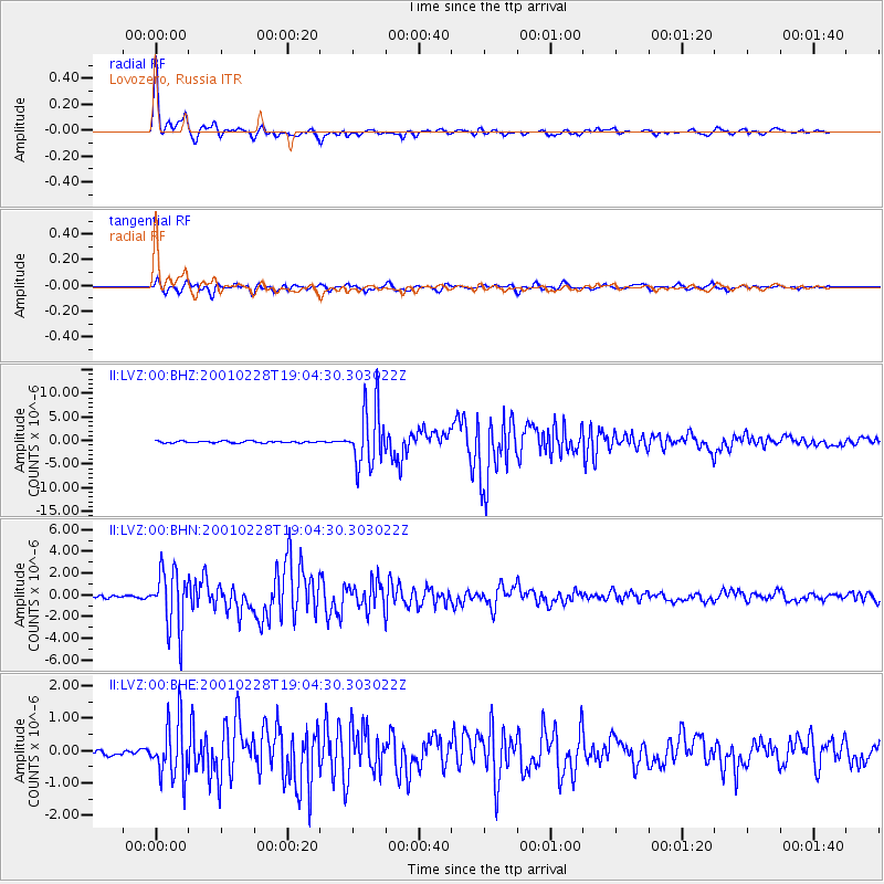
Signal To Noise
| Channel | StoN | STA | LTA |
| II:LVZ:00:BHN:20010228T19:04:30.303022Z | 27.178638 | 2.7106944E-6 | 9.973621E-8 |
| II:LVZ:00:BHE:20010228T19:04:30.303022Z | 8.784564 | 8.7855904E-7 | 1.0001168E-7 |
| II:LVZ:00:BHZ:20010228T19:04:30.303022Z | 30.9193 | 6.2068107E-6 | 2.0074228E-7 |
| Arrivals |
| Ps | 1.6 SECOND |
| PpPs | 4.6 SECOND |
| PsPs/PpSs | 6.2 SECOND |


