You are here: Home > Network List > AG - Arkansas Seismic Network Stations List
> Station CCAR Cane Creek, AR > Earthquake Result Viewer
CCAR Cane Creek, AR - Earthquake Result Viewer
| Earthquake location: |
Kuril Islands |
| Earthquake latitude/longitude: |
44.6/148.7 |
| Earthquake time(UTC): |
2014/07/20 (201) 18:32:47 GMT |
| Earthquake Depth: |
61 km |
| Earthquake Magnitude: |
6.6 MB |
| Earthquake Catalog/Contributor: |
NEIC PDE/NEIC COMCAT |
|
| Network: |
AG Arkansas Seismic Network |
| Station: |
CCAR Cane Creek, AR |
| Lat/Lon: |
33.92 N/91.77 W |
| Elevation: |
72 m |
|
| Distance: |
84.5 deg |
| Az: |
46.648 deg |
| Baz: |
321.362 deg |
| Ray Param: |
0.04534843 |
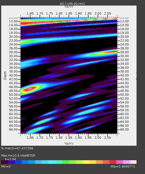
| Estimated Moho Depth: |
10.5 km |
| Estimated Crust Vp/Vs: |
2.04 |
| Assumed Crust Vp: |
6.201 km/s |
| Estimated Crust Vs: |
3.04 km/s |
| Estimated Crust Poisson's Ratio: |
0.34 |
|
| Radial Match: |
87.437256 % |
| Radial Bump: |
400 |
| Transverse Match: |
88.092384 % |
| Transverse Bump: |
400 |
| SOD ConfigId: |
751272 |
| Insert Time: |
2014-08-03 18:42:53.407 +0000 |
| GWidth: |
2.5 |
| Max Bumps: |
400 |
| Tol: |
0.001 |
|

Signal To Noise
| Channel | StoN | STA | LTA |
| AG:CCAR:00:HHZ:20140720T18:44:42.55998Z | 40.504242 | 5.731714E-6 | 1.4150898E-7 |
| AG:CCAR:00:HHN:20140720T18:44:42.55998Z | 4.940754 | 1.340841E-6 | 2.713839E-7 |
| AG:CCAR:00:HHE:20140720T18:44:42.55998Z | 2.6485345 | 7.336299E-7 | 2.7699465E-7 |
| Arrivals |
| Ps | 1.8 SECOND |
| PpPs | 5.0 SECOND |
| PsPs/PpSs | 6.8 SECOND |


