You are here: Home > Network List > AG - Arkansas Seismic Network Stations List
> Station WHAR Woolly Hollow State Park,AR > Earthquake Result Viewer
WHAR Woolly Hollow State Park,AR - Earthquake Result Viewer
| Earthquake location: |
Kuril Islands |
| Earthquake latitude/longitude: |
44.6/148.7 |
| Earthquake time(UTC): |
2014/07/20 (201) 18:32:47 GMT |
| Earthquake Depth: |
61 km |
| Earthquake Magnitude: |
6.6 MB |
| Earthquake Catalog/Contributor: |
NEIC PDE/NEIC COMCAT |
|
| Network: |
AG Arkansas Seismic Network |
| Station: |
WHAR Woolly Hollow State Park,AR |
| Lat/Lon: |
35.29 N/92.29 W |
| Elevation: |
184 m |
|
| Distance: |
83.1 deg |
| Az: |
46.119 deg |
| Baz: |
321.012 deg |
| Ray Param: |
0.04629063 |
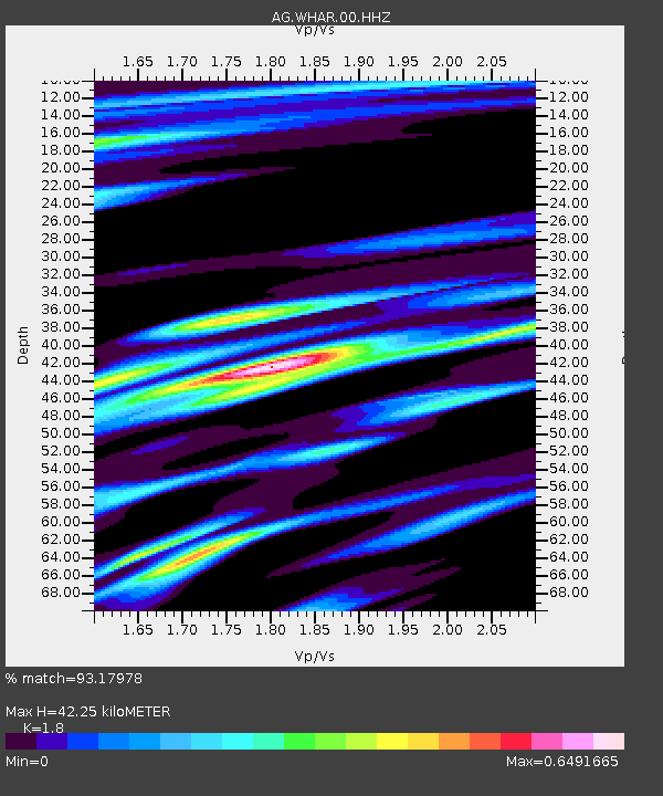
| Estimated Moho Depth: |
42.25 km |
| Estimated Crust Vp/Vs: |
1.80 |
| Assumed Crust Vp: |
6.498 km/s |
| Estimated Crust Vs: |
3.61 km/s |
| Estimated Crust Poisson's Ratio: |
0.28 |
|
| Radial Match: |
93.17978 % |
| Radial Bump: |
400 |
| Transverse Match: |
88.50212 % |
| Transverse Bump: |
317 |
| SOD ConfigId: |
751272 |
| Insert Time: |
2014-08-03 18:43:09.321 +0000 |
| GWidth: |
2.5 |
| Max Bumps: |
400 |
| Tol: |
0.001 |
|

Signal To Noise
| Channel | StoN | STA | LTA |
| AG:WHAR:00:HHZ:20140720T18:44:35.785017Z | 69.253456 | 4.8429515E-6 | 6.993083E-8 |
| AG:WHAR:00:HHN:20140720T18:44:35.785017Z | 18.838757 | 1.3812152E-6 | 7.331775E-8 |
| AG:WHAR:00:HHE:20140720T18:44:35.785017Z | 15.107438 | 8.993601E-7 | 5.9530944E-8 |
| Arrivals |
| Ps | 5.3 SECOND |
| PpPs | 18 SECOND |
| PsPs/PpSs | 23 SECOND |


