You are here: Home > Network List > AG - Arkansas Seismic Network Stations List
> Station WLAR White Oak Lake,AR > Earthquake Result Viewer
WLAR White Oak Lake,AR - Earthquake Result Viewer

| Earthquake location: |
Kuril Islands |
| Earthquake latitude/longitude: |
44.6/148.7 |
| Earthquake time(UTC): |
2014/07/20 (201) 18:32:47 GMT |
| Earthquake Depth: |
61 km |
| Earthquake Magnitude: |
6.6 MB |
| Earthquake Catalog/Contributor: |
NEIC PDE/NEIC COMCAT |
|
| Network: |
AG Arkansas Seismic Network |
| Station: |
WLAR White Oak Lake,AR |
| Lat/Lon: |
33.69 N/93.11 W |
| Elevation: |
77 m |
|
| Distance: |
83.9 deg |
| Az: |
47.665 deg |
| Baz: |
320.722 deg |
| Ray Param: |
0.045717295 |
| Estimated Moho Depth: |
55.25 km |
| Estimated Crust Vp/Vs: |
1.60 |
| Assumed Crust Vp: |
6.245 km/s |
| Estimated Crust Vs: |
3.903 km/s |
| Estimated Crust Poisson's Ratio: |
0.18 |
|
| Radial Match: |
81.95805 % |
| Radial Bump: |
400 |
| Transverse Match: |
86.826996 % |
| Transverse Bump: |
400 |
| SOD ConfigId: |
751272 |
| Insert Time: |
2014-08-03 18:43:11.926 +0000 |
| GWidth: |
2.5 |
| Max Bumps: |
400 |
| Tol: |
0.001 |
|
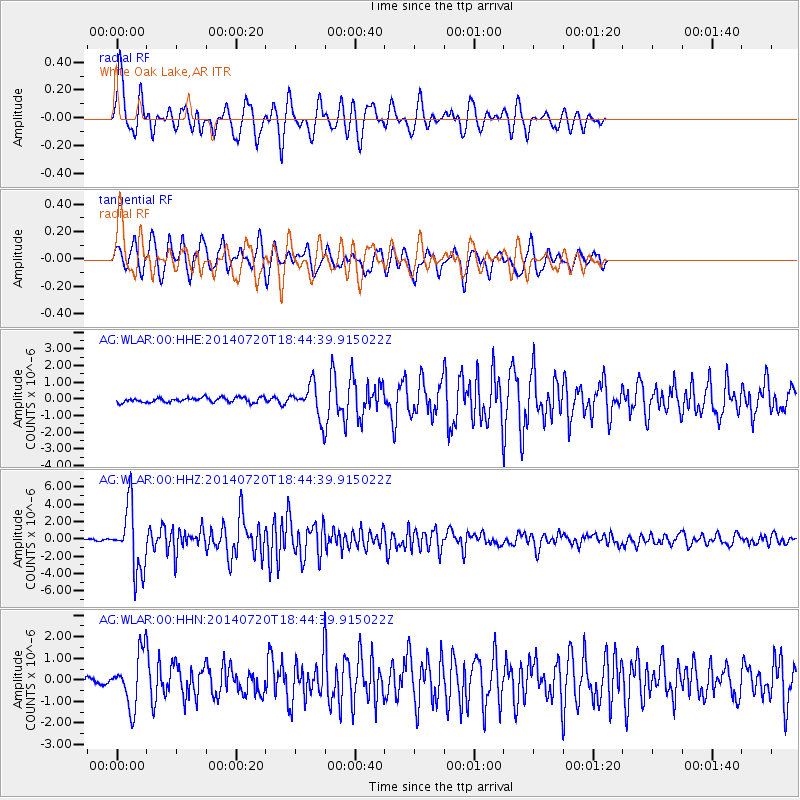
Signal To Noise
| Channel | StoN | STA | LTA |
| AG:WLAR:00:HHZ:20140720T18:44:39.915022Z | 47.881893 | 3.6656081E-6 | 7.65552E-8 |
| AG:WLAR:00:HHN:20140720T18:44:39.915022Z | 6.761519 | 1.2210502E-6 | 1.8058815E-7 |
| AG:WLAR:00:HHE:20140720T18:44:39.915022Z | 6.5156155 | 9.473301E-7 | 1.453938E-7 |
| Arrivals |
| Ps | 5.4 SECOND |
| PpPs | 22 SECOND |
| PsPs/PpSs | 28 SECOND |


