You are here: Home > Network List > AK - Alaska Regional Network Stations List
> Station SSP Sunshine Point, AK, USA > Earthquake Result Viewer
SSP Sunshine Point, AK, USA - Earthquake Result Viewer
| Earthquake location: |
Kuril Islands |
| Earthquake latitude/longitude: |
44.6/148.7 |
| Earthquake time(UTC): |
2014/07/20 (201) 18:32:47 GMT |
| Earthquake Depth: |
61 km |
| Earthquake Magnitude: |
6.6 MB |
| Earthquake Catalog/Contributor: |
NEIC PDE/NEIC COMCAT |
|
| Network: |
AK Alaska Regional Network |
| Station: |
SSP Sunshine Point, AK, USA |
| Lat/Lon: |
60.18 N/142.84 W |
| Elevation: |
474 m |
|
| Distance: |
42.5 deg |
| Az: |
43.497 deg |
| Baz: |
280.456 deg |
| Ray Param: |
0.07298054 |
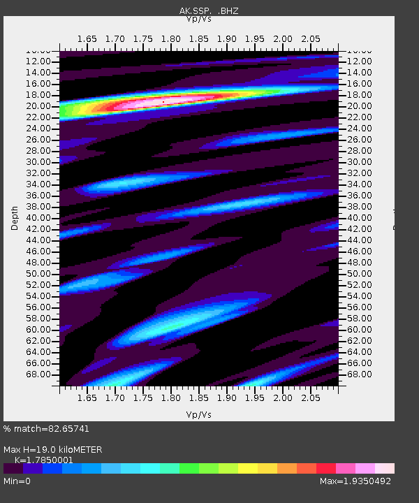
| Estimated Moho Depth: |
19.0 km |
| Estimated Crust Vp/Vs: |
1.79 |
| Assumed Crust Vp: |
6.566 km/s |
| Estimated Crust Vs: |
3.679 km/s |
| Estimated Crust Poisson's Ratio: |
0.27 |
|
| Radial Match: |
82.65741 % |
| Radial Bump: |
400 |
| Transverse Match: |
89.387634 % |
| Transverse Bump: |
400 |
| SOD ConfigId: |
751272 |
| Insert Time: |
2014-08-03 18:47:34.029 +0000 |
| GWidth: |
2.5 |
| Max Bumps: |
400 |
| Tol: |
0.001 |
|

Signal To Noise
| Channel | StoN | STA | LTA |
| AK:SSP: :BHZ:20140720T18:40:06.288008Z | 15.999278 | 9.732507E-6 | 6.083091E-7 |
| AK:SSP: :BHN:20140720T18:40:06.288008Z | 9.624236 | 5.485177E-6 | 5.699337E-7 |
| AK:SSP: :BHE:20140720T18:40:06.288008Z | 6.827459 | 3.8291237E-6 | 5.608417E-7 |
| Arrivals |
| Ps | 2.4 SECOND |
| PpPs | 7.5 SECOND |
| PsPs/PpSs | 10.0 SECOND |


