You are here: Home > Network List > CI - Caltech Regional Seismic Network Stations List
> Station NEE Needles, California, USA > Earthquake Result Viewer
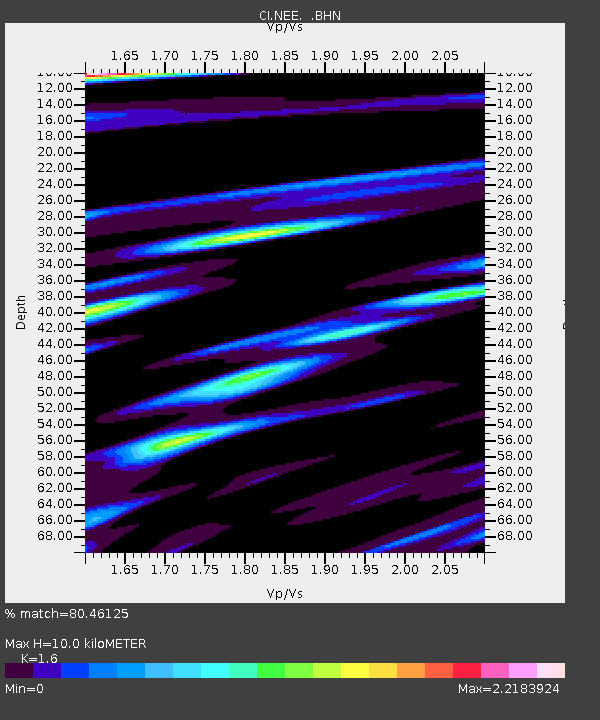
NEE Needles, California, USA - Earthquake Result Viewer
| Earthquake location: |
South Of Kermadec Islands |
| Earthquake latitude/longitude: |
-33.5/-179.5 |
| Earthquake time(UTC): |
1998/04/10 (100) 16:43:41 GMT |
| Earthquake Depth: |
46 km |
| Earthquake Magnitude: |
5.9 MB, 5.9 MS, 6.0 UNKNOWN, 6.0 MW |
| Earthquake Catalog/Contributor: |
WHDF/NEIC |
|
| Network: |
CI Caltech Regional Seismic Network |
| Station: |
NEE Needles, California, USA |
| Lat/Lon: |
34.82 N/114.60 W |
| Elevation: |
139 m |
|
| Distance: |
91.2 deg |
| Az: |
48.198 deg |
| Baz: |
229.177 deg |
| Ray Param: |
0.041609053 |
| Estimated Moho Depth: |
10.0 km |
| Estimated Crust Vp/Vs: |
1.60 |
| Assumed Crust Vp: |
6.276 km/s |
| Estimated Crust Vs: |
3.922 km/s |
| Estimated Crust Poisson's Ratio: |
0.18 |
|
| Radial Match: |
80.46125 % |
| Radial Bump: |
400 |
| Transverse Match: |
73.978386 % |
| Transverse Bump: |
400 |
| SOD ConfigId: |
3770 |
| Insert Time: |
2010-02-25 21:12:17.406 +0000 |
| GWidth: |
2.5 |
| Max Bumps: |
400 |
| Tol: |
0.001 |
|

Signal To Noise
| Channel | StoN | STA | LTA |
| CI:NEE: :BHN:19980410T16:56:10.412Z | 0.92831314 | 4.890397E-7 | 5.268047E-7 |
| CI:NEE: :BHE:19980410T16:56:10.412Z | 1.201604 | 8.405473E-7 | 6.99521E-7 |
| CI:NEE: :BHZ:19980410T16:56:10.412Z | 2.5892022 | 1.7499422E-6 | 6.7586154E-7 |
| Arrivals |
| Ps | 1.0 SECOND |
| PpPs | 4.1 SECOND |
| PsPs/PpSs | 5.0 SECOND |


