You are here: Home > Network List > AZ - ANZA Regional Network Stations List
> Station CRY AZ.CRY > Earthquake Result Viewer
CRY AZ.CRY - Earthquake Result Viewer
| Earthquake location: |
Kuril Islands |
| Earthquake latitude/longitude: |
44.6/148.7 |
| Earthquake time(UTC): |
2014/07/20 (201) 18:32:47 GMT |
| Earthquake Depth: |
61 km |
| Earthquake Magnitude: |
6.6 MB |
| Earthquake Catalog/Contributor: |
NEIC PDE/NEIC COMCAT |
|
| Network: |
AZ ANZA Regional Network |
| Station: |
CRY AZ.CRY |
| Lat/Lon: |
33.57 N/116.74 W |
| Elevation: |
1128 m |
|
| Distance: |
70.2 deg |
| Az: |
62.182 deg |
| Baz: |
310.854 deg |
| Ray Param: |
0.05498406 |
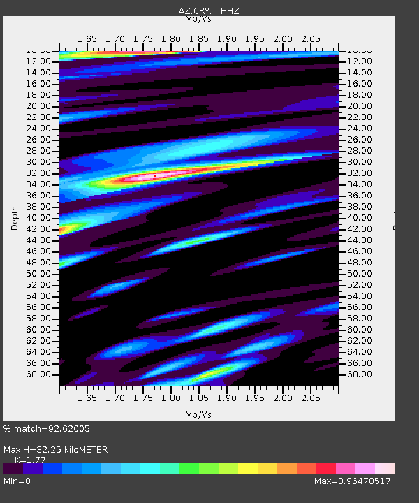
| Estimated Moho Depth: |
32.25 km |
| Estimated Crust Vp/Vs: |
1.77 |
| Assumed Crust Vp: |
6.264 km/s |
| Estimated Crust Vs: |
3.539 km/s |
| Estimated Crust Poisson's Ratio: |
0.27 |
|
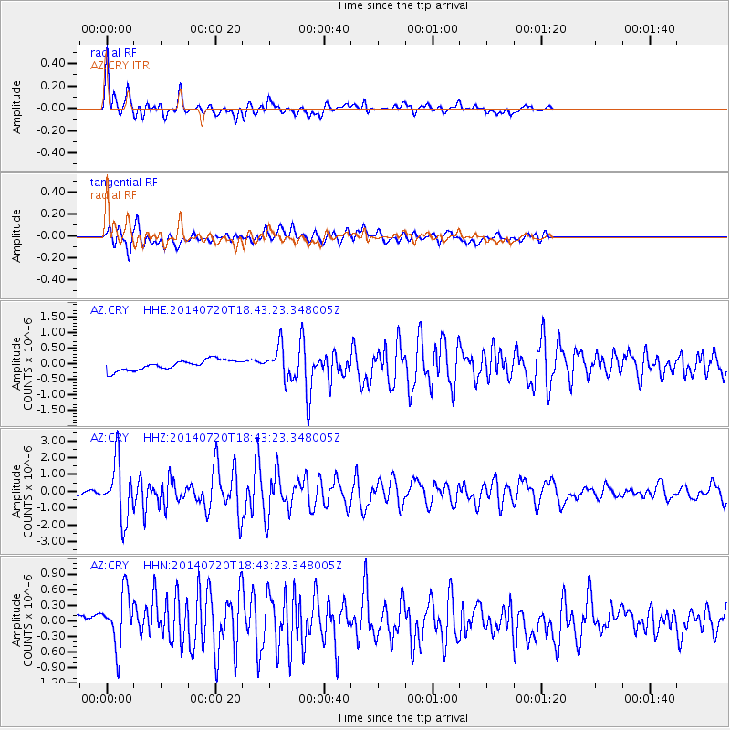
| Radial Match: |
92.62005 % |
| Radial Bump: |
400 |
| Transverse Match: |
75.365974 % |
| Transverse Bump: |
400 |
| SOD ConfigId: |
751272 |
| Insert Time: |
2014-08-03 18:53:01.250 +0000 |
| GWidth: |
2.5 |
| Max Bumps: |
400 |
| Tol: |
0.001 |
|
Signal To Noise
| Channel | StoN | STA | LTA |
| AZ:CRY: :HHZ:20140720T18:43:23.348005Z | 18.117538 | 1.7014652E-6 | 9.3912604E-8 |
| AZ:CRY: :HHN:20140720T18:43:23.348005Z | 3.243906 | 5.400399E-7 | 1.6647827E-7 |
| AZ:CRY: :HHE:20140720T18:43:23.348005Z | 3.080831 | 5.055346E-7 | 1.6409034E-7 |
| Arrivals |
| Ps | 4.1 SECOND |
| PpPs | 14 SECOND |
| PsPs/PpSs | 18 SECOND |


