You are here: Home > Network List > CI - Caltech Regional Seismic Network Stations List
> Station NEE Needles, California, USA > Earthquake Result Viewer
NEE Needles, California, USA - Earthquake Result Viewer
| Earthquake location: |
Peru-Brazil Border Region |
| Earthquake latitude/longitude: |
-8.1/-74.2 |
| Earthquake time(UTC): |
1998/04/03 (093) 22:01:48 GMT |
| Earthquake Depth: |
165 km |
| Earthquake Magnitude: |
6.1 MB, 5.6 MS, 6.6 UNKNOWN, 6.6 MW |
| Earthquake Catalog/Contributor: |
WHDF/NEIC |
|
| Network: |
CI Caltech Regional Seismic Network |
| Station: |
NEE Needles, California, USA |
| Lat/Lon: |
34.82 N/114.60 W |
| Elevation: |
139 m |
|
| Distance: |
57.3 deg |
| Az: |
320.707 deg |
| Baz: |
130.349 deg |
| Ray Param: |
0.06307072 |
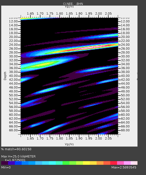
| Estimated Moho Depth: |
25.0 km |
| Estimated Crust Vp/Vs: |
1.97 |
| Assumed Crust Vp: |
6.276 km/s |
| Estimated Crust Vs: |
3.182 km/s |
| Estimated Crust Poisson's Ratio: |
0.33 |
|
| Radial Match: |
90.60158 % |
| Radial Bump: |
400 |
| Transverse Match: |
88.57581 % |
| Transverse Bump: |
400 |
| SOD ConfigId: |
3770 |
| Insert Time: |
2010-02-25 21:12:19.510 +0000 |
| GWidth: |
2.5 |
| Max Bumps: |
400 |
| Tol: |
0.001 |
|

Signal To Noise
| Channel | StoN | STA | LTA |
| CI:NEE: :BHN:19980403T22:10:47.866016Z | 1.5111836 | 5.593895E-7 | 3.7016648E-7 |
| CI:NEE: :BHE:19980403T22:10:47.866016Z | 1.3538064 | 6.5986586E-7 | 4.874152E-7 |
| CI:NEE: :BHZ:19980403T22:10:47.866016Z | 2.340119 | 7.385705E-7 | 3.156124E-7 |
| Arrivals |
| Ps | 4.0 SECOND |
| PpPs | 11 SECOND |
| PsPs/PpSs | 15 SECOND |


