You are here: Home > Network List > CN - Canadian National Seismograph Network Stations List
> Station VIB VAN INLET, BC > Earthquake Result Viewer
VIB VAN INLET, BC - Earthquake Result Viewer
| Earthquake location: |
Kuril Islands |
| Earthquake latitude/longitude: |
44.6/148.7 |
| Earthquake time(UTC): |
2014/07/20 (201) 18:32:47 GMT |
| Earthquake Depth: |
61 km |
| Earthquake Magnitude: |
6.6 MB |
| Earthquake Catalog/Contributor: |
NEIC PDE/NEIC COMCAT |
|
| Network: |
CN Canadian National Seismograph Network |
| Station: |
VIB VAN INLET, BC |
| Lat/Lon: |
53.25 N/132.54 W |
| Elevation: |
1008 m |
|
| Distance: |
50.0 deg |
| Az: |
50.338 deg |
| Baz: |
293.817 deg |
| Ray Param: |
0.06820783 |
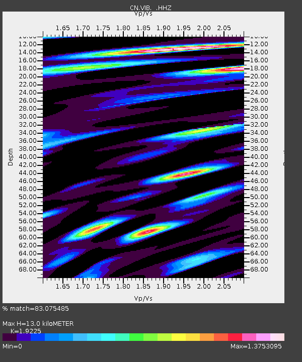
| Estimated Moho Depth: |
13.0 km |
| Estimated Crust Vp/Vs: |
1.92 |
| Assumed Crust Vp: |
6.183 km/s |
| Estimated Crust Vs: |
3.216 km/s |
| Estimated Crust Poisson's Ratio: |
0.31 |
|
| Radial Match: |
83.075485 % |
| Radial Bump: |
400 |
| Transverse Match: |
67.35747 % |
| Transverse Bump: |
400 |
| SOD ConfigId: |
751272 |
| Insert Time: |
2014-08-03 18:59:57.451 +0000 |
| GWidth: |
2.5 |
| Max Bumps: |
400 |
| Tol: |
0.001 |
|
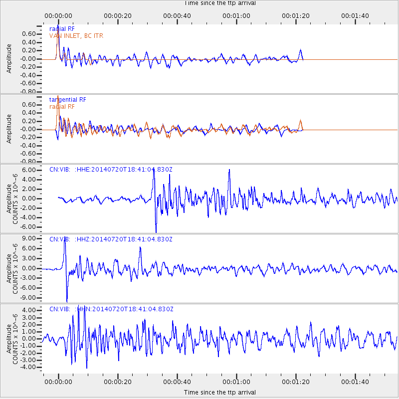
Signal To Noise
| Channel | StoN | STA | LTA |
| CN:VIB: :HHZ:20140720T18:41:04.830Z | 10.736984 | 3.836089E-6 | 3.5727805E-7 |
| CN:VIB: :HHN:20140720T18:41:04.830Z | 2.4347053 | 1.1660968E-6 | 4.789478E-7 |
| CN:VIB: :HHE:20140720T18:41:04.830Z | 7.5742655 | 2.785185E-6 | 3.6771684E-7 |
| Arrivals |
| Ps | 2.0 SECOND |
| PpPs | 5.9 SECOND |
| PsPs/PpSs | 7.9 SECOND |


