You are here: Home > Network List > CO - South Carolina Seismic Network Stations List
> Station HODGE Hodges, SC, USA > Earthquake Result Viewer
HODGE Hodges, SC, USA - Earthquake Result Viewer
| Earthquake location: |
Kuril Islands |
| Earthquake latitude/longitude: |
44.6/148.7 |
| Earthquake time(UTC): |
2014/07/20 (201) 18:32:47 GMT |
| Earthquake Depth: |
61 km |
| Earthquake Magnitude: |
6.6 MB |
| Earthquake Catalog/Contributor: |
NEIC PDE/NEIC COMCAT |
|
| Network: |
CO South Carolina Seismic Network |
| Station: |
HODGE Hodges, SC, USA |
| Lat/Lon: |
34.23 N/82.26 W |
| Elevation: |
151 m |
|
| Distance: |
88.9 deg |
| Az: |
40.082 deg |
| Baz: |
326.294 deg |
| Ray Param: |
0.04215171 |
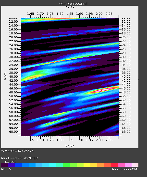
| Estimated Moho Depth: |
46.75 km |
| Estimated Crust Vp/Vs: |
2.01 |
| Assumed Crust Vp: |
6.35 km/s |
| Estimated Crust Vs: |
3.159 km/s |
| Estimated Crust Poisson's Ratio: |
0.34 |
|
| Radial Match: |
86.425575 % |
| Radial Bump: |
400 |
| Transverse Match: |
65.32133 % |
| Transverse Bump: |
400 |
| SOD ConfigId: |
751272 |
| Insert Time: |
2014-08-03 19:01:00.113 +0000 |
| GWidth: |
2.5 |
| Max Bumps: |
400 |
| Tol: |
0.001 |
|

Signal To Noise
| Channel | StoN | STA | LTA |
| CO:HODGE:00:HHZ:20140720T18:45:03.988997Z | 43.34099 | 3.508554E-6 | 8.095233E-8 |
| CO:HODGE:00:HHN:20140720T18:45:03.988997Z | 15.659745 | 9.0604783E-7 | 5.78584E-8 |
| CO:HODGE:00:HHE:20140720T18:45:03.988997Z | 2.4330044 | 5.791727E-7 | 2.3804834E-7 |
| Arrivals |
| Ps | 7.6 SECOND |
| PpPs | 22 SECOND |
| PsPs/PpSs | 29 SECOND |


