You are here: Home > Network List > CI - Caltech Regional Seismic Network Stations List
> Station NEE Needles, California, USA > Earthquake Result Viewer
NEE Needles, California, USA - Earthquake Result Viewer
| Earthquake location: |
Central Peru |
| Earthquake latitude/longitude: |
-11.0/-74.4 |
| Earthquake time(UTC): |
1998/02/19 (050) 04:21:30 GMT |
| Earthquake Depth: |
33 km |
| Earthquake Magnitude: |
5.8 MB, 5.4 MS, 6.0 UNKNOWN, 5.9 MW |
| Earthquake Catalog/Contributor: |
WHDF/NEIC |
|
| Network: |
CI Caltech Regional Seismic Network |
| Station: |
NEE Needles, California, USA |
| Lat/Lon: |
34.82 N/114.60 W |
| Elevation: |
139 m |
|
| Distance: |
59.3 deg |
| Az: |
321.919 deg |
| Baz: |
132.593 deg |
| Ray Param: |
0.062192924 |
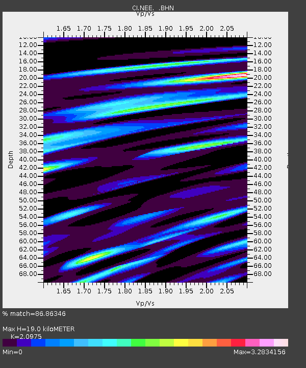
| Estimated Moho Depth: |
19.0 km |
| Estimated Crust Vp/Vs: |
2.10 |
| Assumed Crust Vp: |
6.276 km/s |
| Estimated Crust Vs: |
2.992 km/s |
| Estimated Crust Poisson's Ratio: |
0.35 |
|
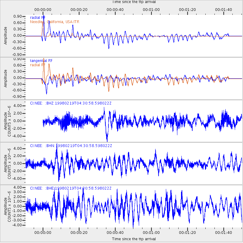
| Radial Match: |
86.86346 % |
| Radial Bump: |
400 |
| Transverse Match: |
87.799614 % |
| Transverse Bump: |
400 |
| SOD ConfigId: |
3770 |
| Insert Time: |
2010-02-25 21:12:20.659 +0000 |
| GWidth: |
2.5 |
| Max Bumps: |
400 |
| Tol: |
0.001 |
|
Signal To Noise
| Channel | StoN | STA | LTA |
| CI:NEE: :BHN:19980219T04:30:58.598022Z | 0.923055 | 6.7741115E-7 | 7.338795E-7 |
| CI:NEE: :BHE:19980219T04:30:58.598022Z | 0.9981927 | 9.1228213E-7 | 9.1393383E-7 |
| CI:NEE: :BHZ:19980219T04:30:58.598022Z | 1.3127633 | 1.188592E-6 | 9.0541226E-7 |
| Arrivals |
| Ps | 3.5 SECOND |
| PpPs | 9.0 SECOND |
| PsPs/PpSs | 12 SECOND |


