You are here: Home > Network List > G - GEOSCOPE Stations List
> Station CLF Chambon la Foret observatory, France > Earthquake Result Viewer
CLF Chambon la Foret observatory, France - Earthquake Result Viewer
| Earthquake location: |
Kuril Islands |
| Earthquake latitude/longitude: |
44.6/148.7 |
| Earthquake time(UTC): |
2014/07/20 (201) 18:32:47 GMT |
| Earthquake Depth: |
61 km |
| Earthquake Magnitude: |
6.6 MB |
| Earthquake Catalog/Contributor: |
NEIC PDE/NEIC COMCAT |
|
| Network: |
G GEOSCOPE |
| Station: |
CLF Chambon la Foret observatory, France |
| Lat/Lon: |
48.03 N/2.26 E |
| Elevation: |
145 m |
|
| Distance: |
83.1 deg |
| Az: |
338.069 deg |
| Baz: |
23.409 deg |
| Ray Param: |
0.046280533 |
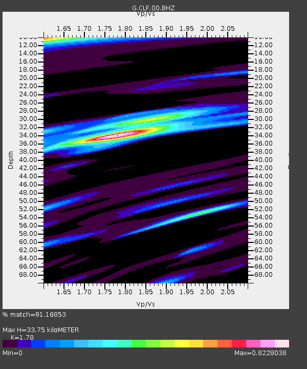
| Estimated Moho Depth: |
33.75 km |
| Estimated Crust Vp/Vs: |
1.78 |
| Assumed Crust Vp: |
6.12 km/s |
| Estimated Crust Vs: |
3.438 km/s |
| Estimated Crust Poisson's Ratio: |
0.27 |
|
| Radial Match: |
91.16853 % |
| Radial Bump: |
293 |
| Transverse Match: |
84.15496 % |
| Transverse Bump: |
370 |
| SOD ConfigId: |
751272 |
| Insert Time: |
2014-08-03 19:02:35.096 +0000 |
| GWidth: |
2.5 |
| Max Bumps: |
400 |
| Tol: |
0.001 |
|

Signal To Noise
| Channel | StoN | STA | LTA |
| G:CLF:00:BHZ:20140720T18:44:35.89897Z | 123.574585 | 1.7692515E-5 | 1.4317277E-7 |
| G:CLF:00:BHN:20140720T18:44:35.89897Z | 19.380129 | 5.101827E-6 | 2.6325043E-7 |
| G:CLF:00:BHE:20140720T18:44:35.89897Z | 7.41042 | 1.2552177E-6 | 1.693855E-7 |
| Arrivals |
| Ps | 4.4 SECOND |
| PpPs | 15 SECOND |
| PsPs/PpSs | 19 SECOND |


