You are here: Home > Network List > GB - Great Britain Seismograph Network Stations List
> Station CCA1 CARNMENELLIS, ENGLAND > Earthquake Result Viewer
CCA1 CARNMENELLIS, ENGLAND - Earthquake Result Viewer
| Earthquake location: |
Kuril Islands |
| Earthquake latitude/longitude: |
44.6/148.7 |
| Earthquake time(UTC): |
2014/07/20 (201) 18:32:47 GMT |
| Earthquake Depth: |
61 km |
| Earthquake Magnitude: |
6.6 MB |
| Earthquake Catalog/Contributor: |
NEIC PDE/NEIC COMCAT |
|
| Network: |
GB Great Britain Seismograph Network |
| Station: |
CCA1 CARNMENELLIS, ENGLAND |
| Lat/Lon: |
50.19 N/5.23 W |
| Elevation: |
209 m |
|
| Distance: |
82.9 deg |
| Az: |
343.475 deg |
| Baz: |
18.419 deg |
| Ray Param: |
0.04646316 |
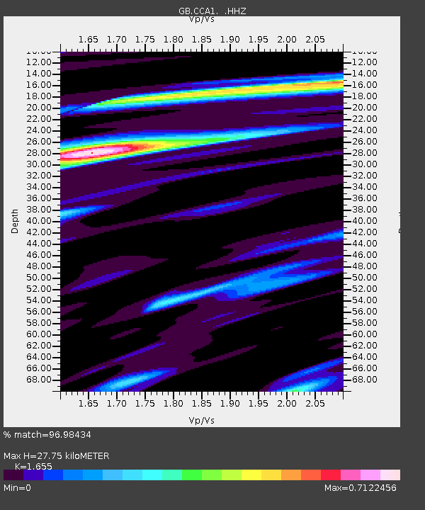
| Estimated Moho Depth: |
27.75 km |
| Estimated Crust Vp/Vs: |
1.65 |
| Assumed Crust Vp: |
6.24 km/s |
| Estimated Crust Vs: |
3.77 km/s |
| Estimated Crust Poisson's Ratio: |
0.21 |
|
| Radial Match: |
96.98434 % |
| Radial Bump: |
372 |
| Transverse Match: |
91.597755 % |
| Transverse Bump: |
400 |
| SOD ConfigId: |
751272 |
| Insert Time: |
2014-08-03 19:02:57.965 +0000 |
| GWidth: |
2.5 |
| Max Bumps: |
400 |
| Tol: |
0.001 |
|

Signal To Noise
| Channel | StoN | STA | LTA |
| GB:CCA1: :HHZ:20140720T18:44:34.509016Z | 149.99188 | 1.5061997E-5 | 1.00418745E-7 |
| GB:CCA1: :HHN:20140720T18:44:34.509016Z | 49.81614 | 5.282551E-6 | 1.0604095E-7 |
| GB:CCA1: :HHE:20140720T18:44:34.509016Z | 14.736596 | 1.85385E-6 | 1.2579906E-7 |
| Arrivals |
| Ps | 3.0 SECOND |
| PpPs | 12 SECOND |
| PsPs/PpSs | 14 SECOND |


