You are here: Home > Network List > IM - International Miscellaneous Stations Stations List
> Station TX32 TXAR Array, Lajitas, TX, USA > Earthquake Result Viewer
TX32 TXAR Array, Lajitas, TX, USA - Earthquake Result Viewer
| Earthquake location: |
Kuril Islands |
| Earthquake latitude/longitude: |
44.6/148.7 |
| Earthquake time(UTC): |
2014/07/20 (201) 18:32:47 GMT |
| Earthquake Depth: |
61 km |
| Earthquake Magnitude: |
6.6 MB |
| Earthquake Catalog/Contributor: |
NEIC PDE/NEIC COMCAT |
|
| Network: |
IM International Miscellaneous Stations |
| Station: |
TX32 TXAR Array, Lajitas, TX, USA |
| Lat/Lon: |
29.33 N/103.67 W |
| Elevation: |
1013 m |
|
| Distance: |
81.2 deg |
| Az: |
57.368 deg |
| Baz: |
316.473 deg |
| Ray Param: |
0.047621448 |
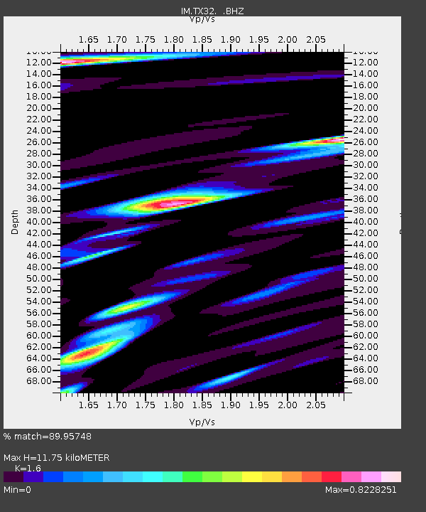
| Estimated Moho Depth: |
11.75 km |
| Estimated Crust Vp/Vs: |
1.60 |
| Assumed Crust Vp: |
6.419 km/s |
| Estimated Crust Vs: |
4.012 km/s |
| Estimated Crust Poisson's Ratio: |
0.18 |
|
| Radial Match: |
89.95748 % |
| Radial Bump: |
400 |
| Transverse Match: |
89.35789 % |
| Transverse Bump: |
400 |
| SOD ConfigId: |
751272 |
| Insert Time: |
2014-08-03 19:09:28.803 +0000 |
| GWidth: |
2.5 |
| Max Bumps: |
400 |
| Tol: |
0.001 |
|

Signal To Noise
| Channel | StoN | STA | LTA |
| IM:TX32: :BHZ:20140720T18:44:25.85002Z | 55.26004 | 1.3620102E-7 | 2.464729E-9 |
| IM:TX32: :BHN:20140720T18:44:25.85002Z | 14.41739 | 2.7931748E-8 | 1.9373652E-9 |
| IM:TX32: :BHE:20140720T18:44:25.85002Z | 22.63298 | 3.836506E-8 | 1.6950953E-9 |
| Arrivals |
| Ps | 1.1 SECOND |
| PpPs | 4.6 SECOND |
| PsPs/PpSs | 5.7 SECOND |


