You are here: Home > Network List > IU - Global Seismograph Network (GSN - IRIS/USGS) Stations List
> Station TEIG Tepich, Yucatan, Mexico > Earthquake Result Viewer
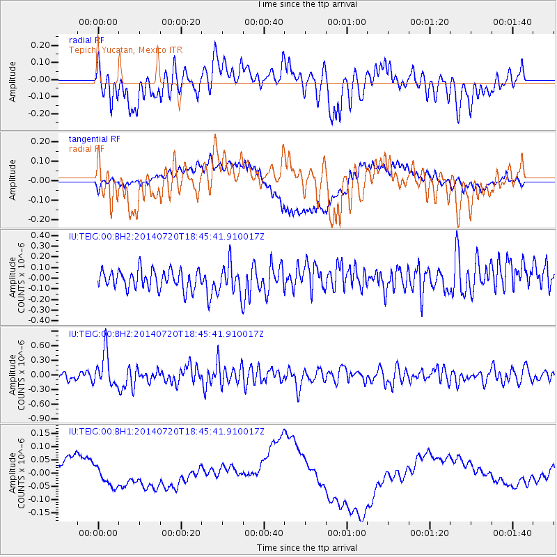
TEIG Tepich, Yucatan, Mexico - Earthquake Result Viewer
*The percent match for this event was below the threshold and hence no stack was calculated.
| Earthquake location: |
Kuril Islands |
| Earthquake latitude/longitude: |
44.6/148.7 |
| Earthquake time(UTC): |
2014/07/20 (201) 18:32:47 GMT |
| Earthquake Depth: |
61 km |
| Earthquake Magnitude: |
6.6 MB |
| Earthquake Catalog/Contributor: |
NEIC PDE/NEIC COMCAT |
|
| Network: |
IU Global Seismograph Network (GSN - IRIS/USGS) |
| Station: |
TEIG Tepich, Yucatan, Mexico |
| Lat/Lon: |
20.23 N/88.28 W |
| Elevation: |
40 m |
|
| Distance: |
97.2 deg |
| Az: |
52.542 deg |
| Baz: |
322.872 deg |
| Ray Param: |
$rayparam |
*The percent match for this event was below the threshold and hence was not used in the summary stack. |
|
| Radial Match: |
47.96032 % |
| Radial Bump: |
400 |
| Transverse Match: |
56.655426 % |
| Transverse Bump: |
400 |
| SOD ConfigId: |
751272 |
| Insert Time: |
2014-08-03 19:11:20.268 +0000 |
| GWidth: |
2.5 |
| Max Bumps: |
400 |
| Tol: |
0.001 |
|
Signal To Noise
| Channel | StoN | STA | LTA |
| IU:TEIG:00:BHZ:20140720T18:45:41.910017Z | 4.0967717 | 3.6308975E-7 | 8.862826E-8 |
| IU:TEIG:00:BH1:20140720T18:45:41.910017Z | 0.35976157 | 3.327939E-8 | 9.250402E-8 |
| IU:TEIG:00:BH2:20140720T18:45:41.910017Z | 1.6265373 | 1.4000659E-7 | 8.607647E-8 |
| Arrivals |
| Ps | |
| PpPs | |
| PsPs/PpSs | |


