You are here: Home > Network List > MN - MEDNET Project Stations List
> Station VSL Villasalto, Italy > Earthquake Result Viewer
VSL Villasalto, Italy - Earthquake Result Viewer

| Earthquake location: |
Kuril Islands |
| Earthquake latitude/longitude: |
44.6/148.7 |
| Earthquake time(UTC): |
2014/07/20 (201) 18:32:47 GMT |
| Earthquake Depth: |
61 km |
| Earthquake Magnitude: |
6.6 MB |
| Earthquake Catalog/Contributor: |
NEIC PDE/NEIC COMCAT |
|
| Network: |
MN MEDNET Project |
| Station: |
VSL Villasalto, Italy |
| Lat/Lon: |
39.50 N/9.38 E |
| Elevation: |
370 m |
|
| Distance: |
88.6 deg |
| Az: |
329.721 deg |
| Baz: |
27.73 deg |
| Ray Param: |
0.04234973 |
| Estimated Moho Depth: |
33.25 km |
| Estimated Crust Vp/Vs: |
1.61 |
| Assumed Crust Vp: |
6.183 km/s |
| Estimated Crust Vs: |
3.84 km/s |
| Estimated Crust Poisson's Ratio: |
0.19 |
|
| Radial Match: |
92.611565 % |
| Radial Bump: |
400 |
| Transverse Match: |
88.94158 % |
| Transverse Bump: |
400 |
| SOD ConfigId: |
751272 |
| Insert Time: |
2014-08-03 19:16:29.586 +0000 |
| GWidth: |
2.5 |
| Max Bumps: |
400 |
| Tol: |
0.001 |
|
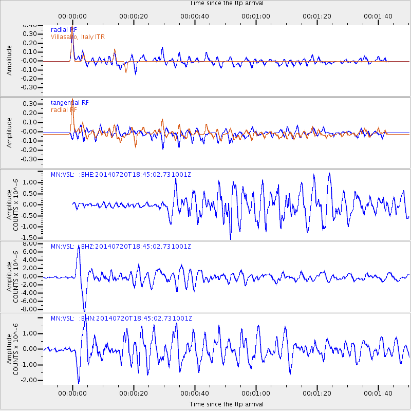
Signal To Noise
| Channel | StoN | STA | LTA |
| MN:VSL: :BHZ:20140720T18:45:02.731001Z | 45.852543 | 4.3693017E-6 | 9.5290275E-8 |
| MN:VSL: :BHN:20140720T18:45:02.731001Z | 16.083214 | 1.143867E-6 | 7.11218E-8 |
| MN:VSL: :BHE:20140720T18:45:02.731001Z | 6.6823673 | 4.925599E-7 | 7.371039E-8 |
| Arrivals |
| Ps | 3.4 SECOND |
| PpPs | 14 SECOND |
| PsPs/PpSs | 17 SECOND |


