You are here: Home > Network List > MX - Mexican National Seismic Network Stations List
> Station HSIG Hermosillo, Son, MX > Earthquake Result Viewer
HSIG Hermosillo, Son, MX - Earthquake Result Viewer
| Earthquake location: |
Kuril Islands |
| Earthquake latitude/longitude: |
44.6/148.7 |
| Earthquake time(UTC): |
2014/07/20 (201) 18:32:47 GMT |
| Earthquake Depth: |
61 km |
| Earthquake Magnitude: |
6.6 MB |
| Earthquake Catalog/Contributor: |
NEIC PDE/NEIC COMCAT |
|
| Network: |
MX Mexican National Seismic Network |
| Station: |
HSIG Hermosillo, Son, MX |
| Lat/Lon: |
29.02 N/110.95 W |
| Elevation: |
250 m |
|
| Distance: |
76.9 deg |
| Az: |
62.19 deg |
| Baz: |
313.852 deg |
| Ray Param: |
0.050530676 |
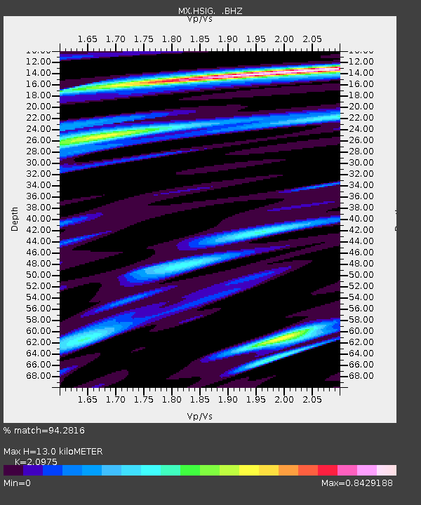
| Estimated Moho Depth: |
13.0 km |
| Estimated Crust Vp/Vs: |
2.10 |
| Assumed Crust Vp: |
6.276 km/s |
| Estimated Crust Vs: |
2.992 km/s |
| Estimated Crust Poisson's Ratio: |
0.35 |
|
| Radial Match: |
94.2816 % |
| Radial Bump: |
400 |
| Transverse Match: |
86.57709 % |
| Transverse Bump: |
400 |
| SOD ConfigId: |
751272 |
| Insert Time: |
2014-08-03 19:16:46.890 +0000 |
| GWidth: |
2.5 |
| Max Bumps: |
400 |
| Tol: |
0.001 |
|

Signal To Noise
| Channel | StoN | STA | LTA |
| MX:HSIG: :BHZ:20140720T18:44:02.62303Z | 34.18305 | 1.3345802E-6 | 3.9042167E-8 |
| MX:HSIG: :BHN:20140720T18:44:02.62303Z | 6.909272 | 2.52161E-7 | 3.649603E-8 |
| MX:HSIG: :BHE:20140720T18:44:02.62303Z | 8.350324 | 3.818984E-7 | 4.573456E-8 |
| Arrivals |
| Ps | 2.3 SECOND |
| PpPs | 6.3 SECOND |
| PsPs/PpSs | 8.6 SECOND |


