You are here: Home > Network List > N4 - Central and EAstern US Network Stations List
> Station L34B Svendsen Farm, Lyons, NE, USA > Earthquake Result Viewer
L34B Svendsen Farm, Lyons, NE, USA - Earthquake Result Viewer
| Earthquake location: |
Kuril Islands |
| Earthquake latitude/longitude: |
44.6/148.7 |
| Earthquake time(UTC): |
2014/07/20 (201) 18:32:47 GMT |
| Earthquake Depth: |
61 km |
| Earthquake Magnitude: |
6.6 MB |
| Earthquake Catalog/Contributor: |
NEIC PDE/NEIC COMCAT |
|
| Network: |
N4 Central and EAstern US Network |
| Station: |
L34B Svendsen Farm, Lyons, NE, USA |
| Lat/Lon: |
41.97 N/96.38 W |
| Elevation: |
414 m |
|
| Distance: |
76.0 deg |
| Az: |
44.205 deg |
| Baz: |
318.118 deg |
| Ray Param: |
0.05117783 |
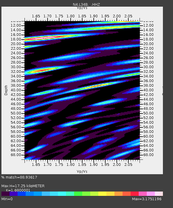
| Estimated Moho Depth: |
17.25 km |
| Estimated Crust Vp/Vs: |
1.68 |
| Assumed Crust Vp: |
6.498 km/s |
| Estimated Crust Vs: |
3.868 km/s |
| Estimated Crust Poisson's Ratio: |
0.23 |
|
| Radial Match: |
88.93617 % |
| Radial Bump: |
400 |
| Transverse Match: |
80.89081 % |
| Transverse Bump: |
400 |
| SOD ConfigId: |
751272 |
| Insert Time: |
2014-08-03 19:19:50.299 +0000 |
| GWidth: |
2.5 |
| Max Bumps: |
400 |
| Tol: |
0.001 |
|

Signal To Noise
| Channel | StoN | STA | LTA |
| N4:L34B: :HHZ:20140720T18:43:57.139998Z | 47.96853 | 4.9769133E-6 | 1.0375372E-7 |
| N4:L34B: :HHN:20140720T18:43:57.139998Z | 18.617495 | 4.0943096E-6 | 2.1991733E-7 |
| N4:L34B: :HHE:20140720T18:43:57.139998Z | 26.680155 | 3.673829E-6 | 1.3769893E-7 |
| Arrivals |
| Ps | 1.9 SECOND |
| PpPs | 6.9 SECOND |
| PsPs/PpSs | 8.7 SECOND |


