You are here: Home > Network List > N4 - Central and EAstern US Network Stations List
> Station U49A Red Boiling Springs, TN, USA > Earthquake Result Viewer
U49A Red Boiling Springs, TN, USA - Earthquake Result Viewer
| Earthquake location: |
Kuril Islands |
| Earthquake latitude/longitude: |
44.6/148.7 |
| Earthquake time(UTC): |
2014/07/20 (201) 18:32:47 GMT |
| Earthquake Depth: |
61 km |
| Earthquake Magnitude: |
6.6 MB |
| Earthquake Catalog/Contributor: |
NEIC PDE/NEIC COMCAT |
|
| Network: |
N4 Central and EAstern US Network |
| Station: |
U49A Red Boiling Springs, TN, USA |
| Lat/Lon: |
36.51 N/85.78 W |
| Elevation: |
234 m |
|
| Distance: |
85.4 deg |
| Az: |
41.154 deg |
| Baz: |
324.318 deg |
| Ray Param: |
0.044701684 |
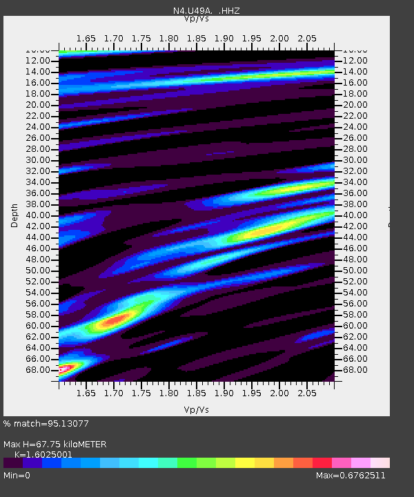
| Estimated Moho Depth: |
67.75 km |
| Estimated Crust Vp/Vs: |
1.60 |
| Assumed Crust Vp: |
6.476 km/s |
| Estimated Crust Vs: |
4.041 km/s |
| Estimated Crust Poisson's Ratio: |
0.18 |
|
| Radial Match: |
95.13077 % |
| Radial Bump: |
400 |
| Transverse Match: |
92.25227 % |
| Transverse Bump: |
400 |
| SOD ConfigId: |
751272 |
| Insert Time: |
2014-08-03 19:21:22.241 +0000 |
| GWidth: |
2.5 |
| Max Bumps: |
400 |
| Tol: |
0.001 |
|

Signal To Noise
| Channel | StoN | STA | LTA |
| N4:U49A: :HHZ:20140720T18:44:47.06999Z | 49.81271 | 4.3275622E-6 | 8.687666E-8 |
| N4:U49A: :HHN:20140720T18:44:47.06999Z | 12.289392 | 9.395832E-7 | 7.645481E-8 |
| N4:U49A: :HHE:20140720T18:44:47.06999Z | 24.368208 | 9.3393E-7 | 3.8325755E-8 |
| Arrivals |
| Ps | 6.5 SECOND |
| PpPs | 27 SECOND |
| PsPs/PpSs | 33 SECOND |


