You are here: Home > Network List > N4 - Central and EAstern US Network Stations List
> Station G45A Suttons Bay, MI, USA > Earthquake Result Viewer
G45A Suttons Bay, MI, USA - Earthquake Result Viewer
| Earthquake location: |
Kuril Islands |
| Earthquake latitude/longitude: |
44.6/148.7 |
| Earthquake time(UTC): |
2014/07/20 (201) 18:32:47 GMT |
| Earthquake Depth: |
61 km |
| Earthquake Magnitude: |
6.6 MB |
| Earthquake Catalog/Contributor: |
NEIC PDE/NEIC COMCAT |
|
| Network: |
N4 Central and EAstern US Network |
| Station: |
G45A Suttons Bay, MI, USA |
| Lat/Lon: |
45.04 N/85.66 W |
| Elevation: |
284 m |
|
| Distance: |
78.5 deg |
| Az: |
36.023 deg |
| Baz: |
323.677 deg |
| Ray Param: |
0.04946166 |
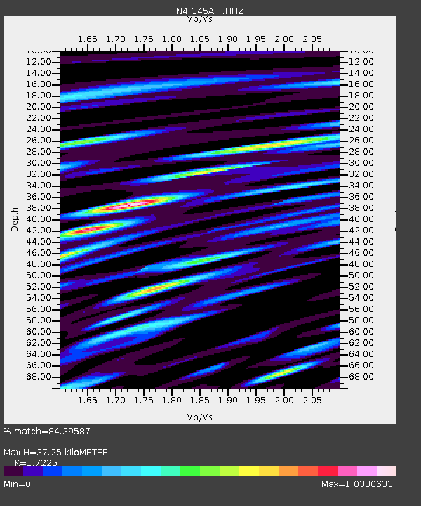
| Estimated Moho Depth: |
37.25 km |
| Estimated Crust Vp/Vs: |
1.72 |
| Assumed Crust Vp: |
6.483 km/s |
| Estimated Crust Vs: |
3.763 km/s |
| Estimated Crust Poisson's Ratio: |
0.25 |
|
| Radial Match: |
84.39587 % |
| Radial Bump: |
400 |
| Transverse Match: |
81.2225 % |
| Transverse Bump: |
400 |
| SOD ConfigId: |
751272 |
| Insert Time: |
2014-08-03 19:23:42.749 +0000 |
| GWidth: |
2.5 |
| Max Bumps: |
400 |
| Tol: |
0.001 |
|

Signal To Noise
| Channel | StoN | STA | LTA |
| N4:G45A: :HHZ:20140720T18:44:11.330Z | 58.906788 | 5.5534733E-6 | 9.4275606E-8 |
| N4:G45A: :HHN:20140720T18:44:11.330Z | 13.561403 | 2.2737063E-6 | 1.676601E-7 |
| N4:G45A: :HHE:20140720T18:44:11.330Z | 12.203079 | 1.7098304E-6 | 1.4011466E-7 |
| Arrivals |
| Ps | 4.3 SECOND |
| PpPs | 15 SECOND |
| PsPs/PpSs | 19 SECOND |


