You are here: Home > Network List > NE - New England Seismic Network Stations List
> Station QUA2 Belchertown, MA, USA > Earthquake Result Viewer
QUA2 Belchertown, MA, USA - Earthquake Result Viewer
| Earthquake location: |
Kuril Islands |
| Earthquake latitude/longitude: |
44.6/148.7 |
| Earthquake time(UTC): |
2014/07/20 (201) 18:32:47 GMT |
| Earthquake Depth: |
61 km |
| Earthquake Magnitude: |
6.6 MB |
| Earthquake Catalog/Contributor: |
NEIC PDE/NEIC COMCAT |
|
| Network: |
NE New England Seismic Network |
| Station: |
QUA2 Belchertown, MA, USA |
| Lat/Lon: |
42.28 N/72.35 W |
| Elevation: |
168 m |
|
| Distance: |
86.0 deg |
| Az: |
29.265 deg |
| Baz: |
331.942 deg |
| Ray Param: |
0.04425413 |
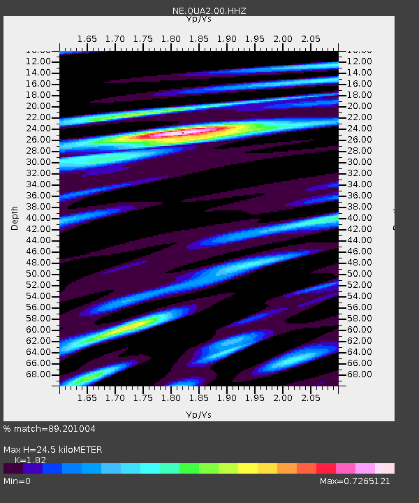
| Estimated Moho Depth: |
24.5 km |
| Estimated Crust Vp/Vs: |
1.82 |
| Assumed Crust Vp: |
6.419 km/s |
| Estimated Crust Vs: |
3.527 km/s |
| Estimated Crust Poisson's Ratio: |
0.28 |
|
| Radial Match: |
89.201004 % |
| Radial Bump: |
400 |
| Transverse Match: |
83.89099 % |
| Transverse Bump: |
400 |
| SOD ConfigId: |
751272 |
| Insert Time: |
2014-08-03 19:24:29.026 +0000 |
| GWidth: |
2.5 |
| Max Bumps: |
400 |
| Tol: |
0.001 |
|

Signal To Noise
| Channel | StoN | STA | LTA |
| NE:QUA2:00:HHZ:20140720T18:44:50.189009Z | 19.342913 | 3.0988447E-6 | 1.602057E-7 |
| NE:QUA2:00:HH1:20140720T18:44:50.189009Z | 7.5471315 | 1.0319245E-6 | 1.3673069E-7 |
| NE:QUA2:00:HH2:20140720T18:44:50.189009Z | 5.8008275 | 6.4778914E-7 | 1.1167184E-7 |
| Arrivals |
| Ps | 3.2 SECOND |
| PpPs | 11 SECOND |
| PsPs/PpSs | 14 SECOND |


