You are here: Home > Network List > NM - Cooperative New Madrid Seismic Network Stations List
> Station SLM St. Louis, MO > Earthquake Result Viewer
SLM St. Louis, MO - Earthquake Result Viewer
| Earthquake location: |
Kuril Islands |
| Earthquake latitude/longitude: |
44.6/148.7 |
| Earthquake time(UTC): |
2014/07/20 (201) 18:32:47 GMT |
| Earthquake Depth: |
61 km |
| Earthquake Magnitude: |
6.6 MB |
| Earthquake Catalog/Contributor: |
NEIC PDE/NEIC COMCAT |
|
| Network: |
NM Cooperative New Madrid Seismic Network |
| Station: |
SLM St. Louis, MO |
| Lat/Lon: |
38.64 N/90.24 W |
| Elevation: |
186 m |
|
| Distance: |
81.5 deg |
| Az: |
42.721 deg |
| Baz: |
321.789 deg |
| Ray Param: |
0.0473923 |
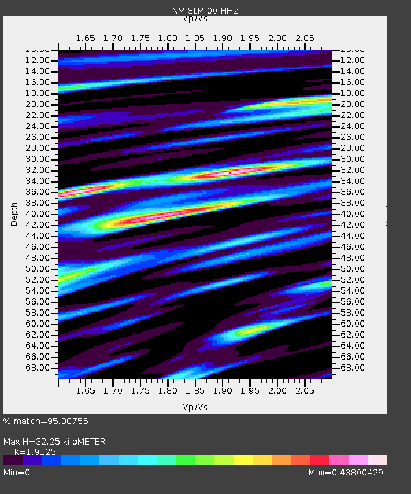
| Estimated Moho Depth: |
32.25 km |
| Estimated Crust Vp/Vs: |
1.91 |
| Assumed Crust Vp: |
6.498 km/s |
| Estimated Crust Vs: |
3.397 km/s |
| Estimated Crust Poisson's Ratio: |
0.31 |
|
| Radial Match: |
95.30755 % |
| Radial Bump: |
352 |
| Transverse Match: |
77.33173 % |
| Transverse Bump: |
400 |
| SOD ConfigId: |
751272 |
| Insert Time: |
2014-08-03 19:26:45.260 +0000 |
| GWidth: |
2.5 |
| Max Bumps: |
400 |
| Tol: |
0.001 |
|

Signal To Noise
| Channel | StoN | STA | LTA |
| NM:SLM:00:HHZ:20140720T18:44:27.548994Z | 43.75269 | 5.065078E-6 | 1.15766085E-7 |
| NM:SLM:00:HHN:20140720T18:44:27.548994Z | 15.573629 | 1.364397E-6 | 8.760944E-8 |
| NM:SLM:00:HHE:20140720T18:44:27.548994Z | 9.441989 | 9.645297E-7 | 1.0215323E-7 |
| Arrivals |
| Ps | 4.6 SECOND |
| PpPs | 14 SECOND |
| PsPs/PpSs | 19 SECOND |


