You are here: Home > Network List > NM - Cooperative New Madrid Seismic Network Stations List
> Station UTMT Martin, TN > Earthquake Result Viewer
UTMT Martin, TN - Earthquake Result Viewer
| Earthquake location: |
Kuril Islands |
| Earthquake latitude/longitude: |
44.6/148.7 |
| Earthquake time(UTC): |
2014/07/20 (201) 18:32:47 GMT |
| Earthquake Depth: |
61 km |
| Earthquake Magnitude: |
6.6 MB |
| Earthquake Catalog/Contributor: |
NEIC PDE/NEIC COMCAT |
|
| Network: |
NM Cooperative New Madrid Seismic Network |
| Station: |
UTMT Martin, TN |
| Lat/Lon: |
36.35 N/88.86 W |
| Elevation: |
110 m |
|
| Distance: |
84.0 deg |
| Az: |
43.259 deg |
| Baz: |
322.688 deg |
| Ray Param: |
0.04566418 |
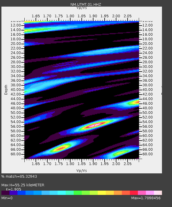
| Estimated Moho Depth: |
55.25 km |
| Estimated Crust Vp/Vs: |
1.90 |
| Assumed Crust Vp: |
6.444 km/s |
| Estimated Crust Vs: |
3.383 km/s |
| Estimated Crust Poisson's Ratio: |
0.31 |
|
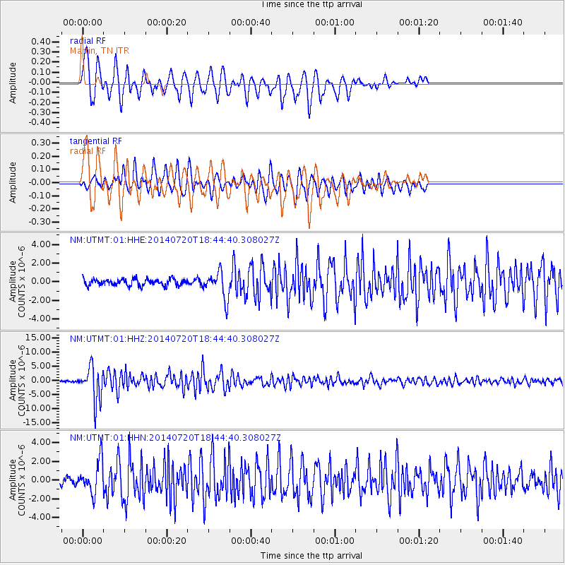
| Radial Match: |
85.32943 % |
| Radial Bump: |
400 |
| Transverse Match: |
75.25987 % |
| Transverse Bump: |
400 |
| SOD ConfigId: |
751272 |
| Insert Time: |
2014-08-03 19:26:54.821 +0000 |
| GWidth: |
2.5 |
| Max Bumps: |
400 |
| Tol: |
0.001 |
|
Signal To Noise
| Channel | StoN | STA | LTA |
| NM:UTMT:01:HHZ:20140720T18:44:40.308027Z | 33.654976 | 6.0517527E-6 | 1.7981748E-7 |
| NM:UTMT:01:HHN:20140720T18:44:40.308027Z | 5.5703664 | 1.7914208E-6 | 3.2159838E-7 |
| NM:UTMT:01:HHE:20140720T18:44:40.308027Z | 4.236012 | 1.4832477E-6 | 3.5015194E-7 |
| Arrivals |
| Ps | 7.9 SECOND |
| PpPs | 24 SECOND |
| PsPs/PpSs | 32 SECOND |


