You are here: Home > Network List > AK - Alaska Regional Network Stations List
> Station CHI Chirikof Island > Earthquake Result Viewer
CHI Chirikof Island - Earthquake Result Viewer
| Earthquake location: |
Fiji Islands Region |
| Earthquake latitude/longitude: |
-19.8/-178.4 |
| Earthquake time(UTC): |
2014/07/21 (202) 14:54:40 GMT |
| Earthquake Depth: |
616 km |
| Earthquake Magnitude: |
6.9 MWB, 6.9 MI |
| Earthquake Catalog/Contributor: |
NEIC PDE/NEIC ALERT |
|
| Network: |
AK Alaska Regional Network |
| Station: |
CHI Chirikof Island |
| Lat/Lon: |
55.82 N/155.62 W |
| Elevation: |
234 m |
|
| Distance: |
77.8 deg |
| Az: |
12.943 deg |
| Baz: |
201.947 deg |
| Ray Param: |
0.048142243 |
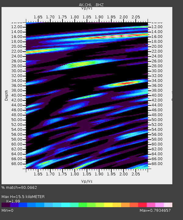
| Estimated Moho Depth: |
15.5 km |
| Estimated Crust Vp/Vs: |
1.99 |
| Assumed Crust Vp: |
3.999 km/s |
| Estimated Crust Vs: |
2.009 km/s |
| Estimated Crust Poisson's Ratio: |
0.33 |
|
| Radial Match: |
80.0662 % |
| Radial Bump: |
400 |
| Transverse Match: |
66.52654 % |
| Transverse Bump: |
400 |
| SOD ConfigId: |
751272 |
| Insert Time: |
2014-08-04 15:05:45.831 +0000 |
| GWidth: |
2.5 |
| Max Bumps: |
400 |
| Tol: |
0.001 |
|

Signal To Noise
| Channel | StoN | STA | LTA |
| AK:CHI: :BHZ:20140721T15:05:04.688025Z | 15.182465 | 1.2845205E-5 | 8.460553E-7 |
| AK:CHI: :BHN:20140721T15:05:04.688025Z | 3.8054028 | 2.9396965E-6 | 7.7250604E-7 |
| AK:CHI: :BHE:20140721T15:05:04.688025Z | 3.2826507 | 2.2632569E-6 | 6.8946014E-7 |
| Arrivals |
| Ps | 3.9 SECOND |
| PpPs | 11 SECOND |
| PsPs/PpSs | 15 SECOND |


