You are here: Home > Network List > AT - Alaska Tsunami Warning Seismic System Stations List
> Station PMR Palmer, Alaska > Earthquake Result Viewer
PMR Palmer, Alaska - Earthquake Result Viewer
| Earthquake location: |
Fiji Islands Region |
| Earthquake latitude/longitude: |
-19.8/-178.4 |
| Earthquake time(UTC): |
2014/07/21 (202) 14:54:40 GMT |
| Earthquake Depth: |
616 km |
| Earthquake Magnitude: |
6.9 MWB, 6.9 MI |
| Earthquake Catalog/Contributor: |
NEIC PDE/NEIC ALERT |
|
| Network: |
AT Alaska Tsunami Warning Seismic System |
| Station: |
PMR Palmer, Alaska |
| Lat/Lon: |
61.59 N/149.13 W |
| Elevation: |
100 m |
|
| Distance: |
84.4 deg |
| Az: |
13.605 deg |
| Baz: |
207.594 deg |
| Ray Param: |
0.0436609 |
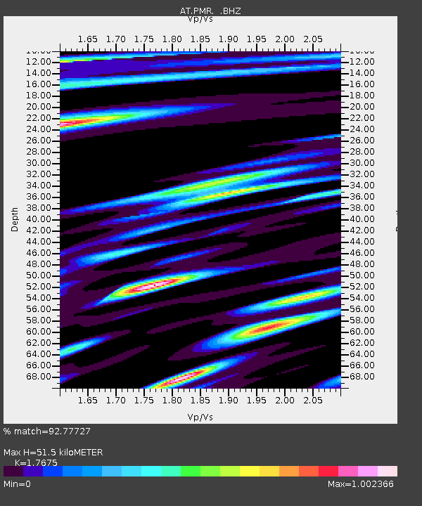
| Estimated Moho Depth: |
51.5 km |
| Estimated Crust Vp/Vs: |
1.77 |
| Assumed Crust Vp: |
6.566 km/s |
| Estimated Crust Vs: |
3.715 km/s |
| Estimated Crust Poisson's Ratio: |
0.26 |
|
| Radial Match: |
92.77727 % |
| Radial Bump: |
400 |
| Transverse Match: |
84.59973 % |
| Transverse Bump: |
400 |
| SOD ConfigId: |
751272 |
| Insert Time: |
2014-08-04 15:11:30.346 +0000 |
| GWidth: |
2.5 |
| Max Bumps: |
400 |
| Tol: |
0.001 |
|

Signal To Noise
| Channel | StoN | STA | LTA |
| AT:PMR: :BHZ:20140721T15:05:38.63999Z | 107.30337 | 8.104945E-6 | 7.5532995E-8 |
| AT:PMR: :BHN:20140721T15:05:38.63999Z | 20.163317 | 1.713959E-6 | 8.500382E-8 |
| AT:PMR: :BHE:20140721T15:05:38.63999Z | 24.679981 | 2.0571858E-6 | 8.335443E-8 |
| Arrivals |
| Ps | 6.2 SECOND |
| PpPs | 21 SECOND |
| PsPs/PpSs | 27 SECOND |


