You are here: Home > Network List > BK - Berkeley Digital Seismograph Network Stations List
> Station MCCM Marconi Conference Center, Marshall, CA, USA > Earthquake Result Viewer
MCCM Marconi Conference Center, Marshall, CA, USA - Earthquake Result Viewer
| Earthquake location: |
Fiji Islands Region |
| Earthquake latitude/longitude: |
-19.8/-178.4 |
| Earthquake time(UTC): |
2014/07/21 (202) 14:54:40 GMT |
| Earthquake Depth: |
616 km |
| Earthquake Magnitude: |
6.9 MWB, 6.9 MI |
| Earthquake Catalog/Contributor: |
NEIC PDE/NEIC ALERT |
|
| Network: |
BK Berkeley Digital Seismograph Network |
| Station: |
MCCM Marconi Conference Center, Marshall, CA, USA |
| Lat/Lon: |
38.14 N/122.88 W |
| Elevation: |
-7.7 m |
|
| Distance: |
77.7 deg |
| Az: |
41.724 deg |
| Baz: |
232.646 deg |
| Ray Param: |
0.04817453 |
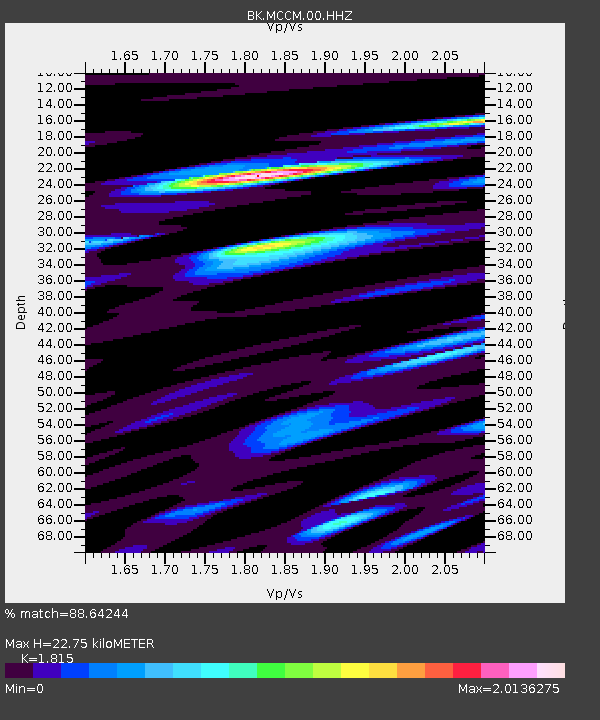
| Estimated Moho Depth: |
22.75 km |
| Estimated Crust Vp/Vs: |
1.82 |
| Assumed Crust Vp: |
6.472 km/s |
| Estimated Crust Vs: |
3.566 km/s |
| Estimated Crust Poisson's Ratio: |
0.28 |
|
| Radial Match: |
88.64244 % |
| Radial Bump: |
400 |
| Transverse Match: |
77.954285 % |
| Transverse Bump: |
400 |
| SOD ConfigId: |
751272 |
| Insert Time: |
2014-08-04 15:19:07.239 +0000 |
| GWidth: |
2.5 |
| Max Bumps: |
400 |
| Tol: |
0.001 |
|
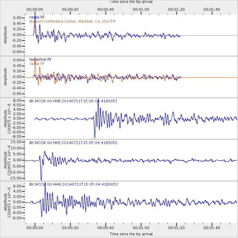
Signal To Noise
| Channel | StoN | STA | LTA |
| BK:MCCM:00:HHZ:20140721T15:05:04.418005Z | 40.073395 | 4.967332E-6 | 1.2395586E-7 |
| BK:MCCM:00:HHN:20140721T15:05:04.418005Z | 7.614362 | 1.5541208E-6 | 2.0410388E-7 |
| BK:MCCM:00:HHE:20140721T15:05:04.418005Z | 10.244512 | 2.4694864E-6 | 2.4105458E-7 |
| Arrivals |
| Ps | 2.9 SECOND |
| PpPs | 9.6 SECOND |
| PsPs/PpSs | 13 SECOND |


