You are here: Home > Network List > CI - Caltech Regional Seismic Network Stations List
> Station NEE Needles, California, USA > Earthquake Result Viewer
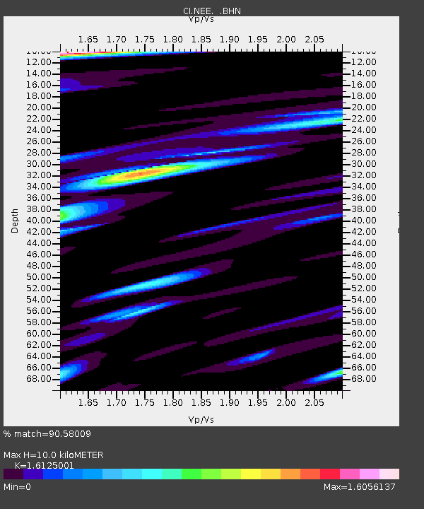
NEE Needles, California, USA - Earthquake Result Viewer
| Earthquake location: |
Fiji Islands Region |
| Earthquake latitude/longitude: |
-17.6/-179.1 |
| Earthquake time(UTC): |
1998/03/29 (088) 19:48:16 GMT |
| Earthquake Depth: |
537 km |
| Earthquake Magnitude: |
6.5 MB, 7.2 UNKNOWN, 7.1 MW |
| Earthquake Catalog/Contributor: |
WHDF/NEIC |
|
| Network: |
CI Caltech Regional Seismic Network |
| Station: |
NEE Needles, California, USA |
| Lat/Lon: |
34.82 N/114.60 W |
| Elevation: |
139 m |
|
| Distance: |
80.4 deg |
| Az: |
48.865 deg |
| Baz: |
240.855 deg |
| Ray Param: |
0.046729166 |
| Estimated Moho Depth: |
10.0 km |
| Estimated Crust Vp/Vs: |
1.61 |
| Assumed Crust Vp: |
6.276 km/s |
| Estimated Crust Vs: |
3.892 km/s |
| Estimated Crust Poisson's Ratio: |
0.19 |
|
| Radial Match: |
90.58009 % |
| Radial Bump: |
400 |
| Transverse Match: |
91.463104 % |
| Transverse Bump: |
400 |
| SOD ConfigId: |
6273 |
| Insert Time: |
2010-02-25 21:12:31.324 +0000 |
| GWidth: |
2.5 |
| Max Bumps: |
400 |
| Tol: |
0.001 |
|

Signal To Noise
| Channel | StoN | STA | LTA |
| CI:NEE: :BHN:19980329T19:59:00.413013Z | 1.8177016 | 2.3106415E-6 | 1.2711887E-6 |
| CI:NEE: :BHE:19980329T19:59:00.413013Z | 1.7514592 | 3.7378197E-6 | 2.1341175E-6 |
| CI:NEE: :BHZ:19980329T19:59:00.413013Z | 12.491723 | 1.4938383E-5 | 1.1958625E-6 |
| Arrivals |
| Ps | 1.0 SECOND |
| PpPs | 4.0 SECOND |
| PsPs/PpSs | 5.1 SECOND |


