You are here: Home > Network List > CN - Canadian National Seismograph Network Stations List
> Station VIB VAN INLET, BC > Earthquake Result Viewer
VIB VAN INLET, BC - Earthquake Result Viewer
| Earthquake location: |
Fiji Islands Region |
| Earthquake latitude/longitude: |
-19.8/-178.4 |
| Earthquake time(UTC): |
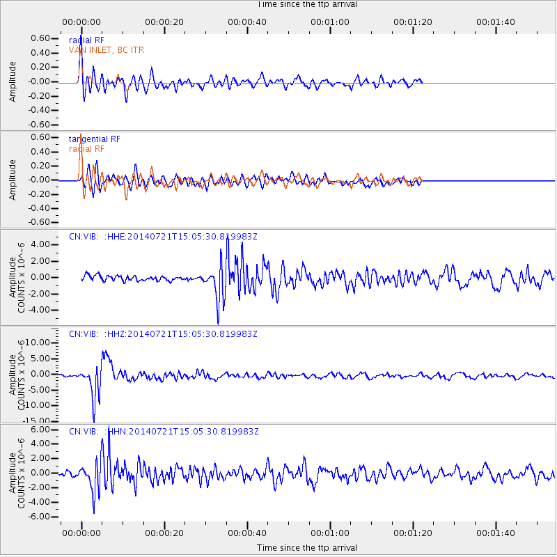
2014/07/21 (202) 14:54:40 GMT |
| Earthquake Depth: |
616 km |
| Earthquake Magnitude: |
6.9 MWB, 6.9 MI |
| Earthquake Catalog/Contributor: |
NEIC PDE/NEIC ALERT |
|
| Network: |
CN Canadian National Seismograph Network |
| Station: |
VIB VAN INLET, BC |
| Lat/Lon: |
53.25 N/132.54 W |
| Elevation: |
1008 m |
|
| Distance: |
82.8 deg |
| Az: |
25.78 deg |
| Baz: |
222.97 deg |
| Ray Param: |
0.044749852 |
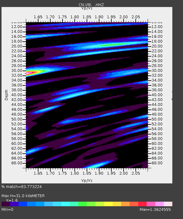
| Estimated Moho Depth: |
31.0 km |
| Estimated Crust Vp/Vs: |
1.60 |
| Assumed Crust Vp: |
6.183 km/s |
| Estimated Crust Vs: |
3.864 km/s |
| Estimated Crust Poisson's Ratio: |
0.18 |
|
| Radial Match: |
83.773224 % |
| Radial Bump: |
400 |
| Transverse Match: |
71.27133 % |
| Transverse Bump: |
400 |
| SOD ConfigId: |
751272 |
| Insert Time: |
2014-08-04 15:22:47.514 +0000 |
| GWidth: |
2.5 |
| Max Bumps: |
400 |
| Tol: |
0.001 |
|
Signal To Noise
| Channel | StoN | STA | LTA |
| CN:VIB: :HHZ:20140721T15:05:30.819983Z | 22.268951 | 5.031934E-6 | 2.2596187E-7 |
| CN:VIB: :HHN:20140721T15:05:30.819983Z | 5.7837214 | 1.954301E-6 | 3.3789684E-7 |
| CN:VIB: :HHE:20140721T15:05:30.819983Z | 7.0467095 | 2.1281367E-6 | 3.0200434E-7 |
| Arrivals |
| Ps | 3.1 SECOND |
| PpPs | 13 SECOND |
| PsPs/PpSs | 16 SECOND |


