You are here: Home > Network List > IM - International Miscellaneous Stations Stations List
> Station TX31 TXAR Array, Lajitas, TX, USA > Earthquake Result Viewer
TX31 TXAR Array, Lajitas, TX, USA - Earthquake Result Viewer
| Earthquake location: |
Fiji Islands Region |
| Earthquake latitude/longitude: |
-19.8/-178.4 |
| Earthquake time(UTC): |
2014/07/21 (202) 14:54:40 GMT |
| Earthquake Depth: |
616 km |
| Earthquake Magnitude: |
6.9 MWB, 6.9 MI |
| Earthquake Catalog/Contributor: |
NEIC PDE/NEIC ALERT |
|
| Network: |
IM International Miscellaneous Stations |
| Station: |
TX31 TXAR Array, Lajitas, TX, USA |
| Lat/Lon: |
29.33 N/103.67 W |
| Elevation: |
1025 m |
|
| Distance: |
87.0 deg |
| Az: |
57.529 deg |
| Baz: |
245.49 deg |
| Ray Param: |
0.04184392 |
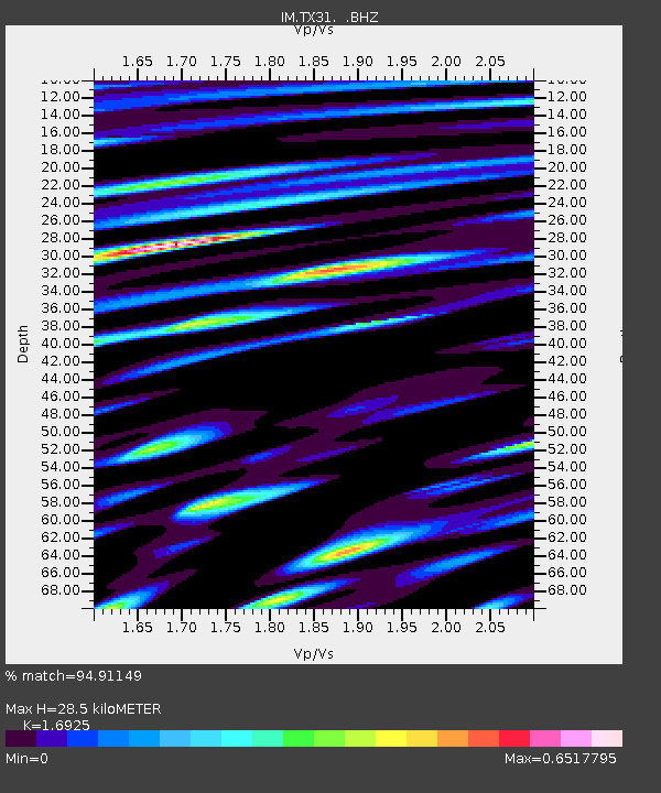
| Estimated Moho Depth: |
28.5 km |
| Estimated Crust Vp/Vs: |
1.69 |
| Assumed Crust Vp: |
6.419 km/s |
| Estimated Crust Vs: |
3.793 km/s |
| Estimated Crust Poisson's Ratio: |
0.23 |
|
| Radial Match: |
94.91149 % |
| Radial Bump: |
400 |
| Transverse Match: |
92.53888 % |
| Transverse Bump: |
400 |
| SOD ConfigId: |
751272 |
| Insert Time: |
2014-08-04 15:28:10.869 +0000 |
| GWidth: |
2.5 |
| Max Bumps: |
400 |
| Tol: |
0.001 |
|

Signal To Noise
| Channel | StoN | STA | LTA |
| IM:TX31: :BHZ:20140721T15:05:50.998999Z | 127.56721 | 3.178666E-5 | 2.4917583E-7 |
| IM:TX31: :BHN:20140721T15:05:50.998999Z | 51.354946 | 8.542559E-6 | 1.6634345E-7 |
| IM:TX31: :BHE:20140721T15:05:50.998999Z | 42.41035 | 6.3776642E-6 | 1.503799E-7 |
| Arrivals |
| Ps | 3.1 SECOND |
| PpPs | 12 SECOND |
| PsPs/PpSs | 15 SECOND |


