You are here: Home > Network List > JP - Japan Meteorological Agency Seismic Network Stations List
> Station JHJ2 Hachijojima Island > Earthquake Result Viewer
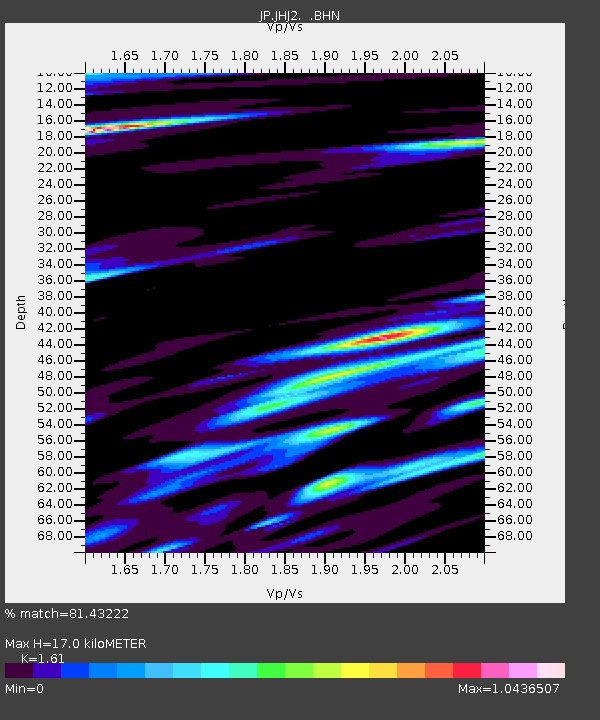
JHJ2 Hachijojima Island - Earthquake Result Viewer
| Earthquake location: |
Fiji Islands Region |
| Earthquake latitude/longitude: |
-19.8/-178.4 |
| Earthquake time(UTC): |
2014/07/21 (202) 14:54:40 GMT |
| Earthquake Depth: |
616 km |
| Earthquake Magnitude: |
6.9 MWB, 6.9 MI |
| Earthquake Catalog/Contributor: |
NEIC PDE/NEIC ALERT |
|
| Network: |
JP Japan Meteorological Agency Seismic Network |
| Station: |
JHJ2 Hachijojima Island |
| Lat/Lon: |
33.12 N/139.81 E |
| Elevation: |
70 m |
|
| Distance: |
66.0 deg |
| Az: |
322.289 deg |
| Baz: |
136.657 deg |
| Ray Param: |
0.055612102 |
| Estimated Moho Depth: |
17.0 km |
| Estimated Crust Vp/Vs: |
1.61 |
| Assumed Crust Vp: |
4.662 km/s |
| Estimated Crust Vs: |
2.896 km/s |
| Estimated Crust Poisson's Ratio: |
0.19 |
|
| Radial Match: |
81.43222 % |
| Radial Bump: |
400 |
| Transverse Match: |
85.764626 % |
| Transverse Bump: |
400 |
| SOD ConfigId: |
751272 |
| Insert Time: |
2014-08-04 15:31:14.107 +0000 |
| GWidth: |
2.5 |
| Max Bumps: |
400 |
| Tol: |
0.001 |
|

Signal To Noise
| Channel | StoN | STA | LTA |
| JP:JHJ2: :BHZ:20140721T15:03:57.100012Z | 39.836464 | 3.3777455E-5 | 8.47903E-7 |
| JP:JHJ2: :BHN:20140721T15:03:57.100012Z | 19.707184 | 1.7144732E-5 | 8.699737E-7 |
| JP:JHJ2: :BHE:20140721T15:03:57.100012Z | 12.5320835 | 1.5286341E-5 | 1.2197765E-6 |
| Arrivals |
| Ps | 2.3 SECOND |
| PpPs | 9.3 SECOND |
| PsPs/PpSs | 12 SECOND |


