You are here: Home > Network List > MX - Mexican National Seismic Network Stations List
> Station ZAIG Zacatecas, Zac, MX > Earthquake Result Viewer
ZAIG Zacatecas, Zac, MX - Earthquake Result Viewer
| Earthquake location: |
Fiji Islands Region |
| Earthquake latitude/longitude: |
-19.8/-178.4 |
| Earthquake time(UTC): |
2014/07/21 (202) 14:54:40 GMT |
| Earthquake Depth: |
616 km |
| Earthquake Magnitude: |
6.9 MWB, 6.9 MI |
| Earthquake Catalog/Contributor: |
NEIC PDE/NEIC ALERT |
|
| Network: |
MX Mexican National Seismic Network |
| Station: |
ZAIG Zacatecas, Zac, MX |
| Lat/Lon: |
22.77 N/102.57 W |
| Elevation: |
2408 m |
|
| Distance: |
85.3 deg |
| Az: |
63.917 deg |
| Baz: |
246.403 deg |
| Ray Param: |
0.04308249 |
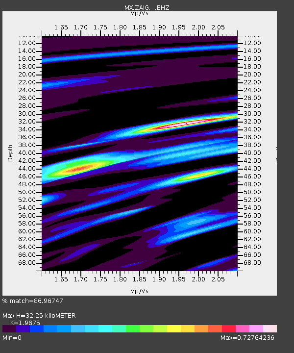
| Estimated Moho Depth: |
32.25 km |
| Estimated Crust Vp/Vs: |
1.97 |
| Assumed Crust Vp: |
6.597 km/s |
| Estimated Crust Vs: |
3.353 km/s |
| Estimated Crust Poisson's Ratio: |
0.33 |
|
| Radial Match: |
86.96747 % |
| Radial Bump: |
400 |
| Transverse Match: |
84.71688 % |
| Transverse Bump: |
400 |
| SOD ConfigId: |
751272 |
| Insert Time: |
2014-08-04 15:32:28.105 +0000 |
| GWidth: |
2.5 |
| Max Bumps: |
400 |
| Tol: |
0.001 |
|

Signal To Noise
| Channel | StoN | STA | LTA |
| MX:ZAIG: :BHZ:20140721T15:05:42.717017Z | 32.292664 | 1.6877947E-6 | 5.2265573E-8 |
| MX:ZAIG: :BHN:20140721T15:05:42.717017Z | 6.0367866 | 3.099169E-7 | 5.133806E-8 |
| MX:ZAIG: :BHE:20140721T15:05:42.717017Z | 6.4844213 | 3.808368E-7 | 5.8731043E-8 |
| Arrivals |
| Ps | 4.8 SECOND |
| PpPs | 14 SECOND |
| PsPs/PpSs | 19 SECOND |


