You are here: Home > Network List > TA - USArray Transportable Network (new EarthScope stations) Stations List
> Station G05D Wamic, OR, USA > Earthquake Result Viewer
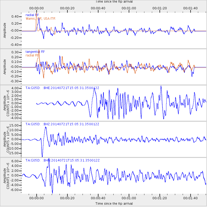
G05D Wamic, OR, USA - Earthquake Result Viewer
*The percent match for this event was below the threshold and hence no stack was calculated.
| Earthquake location: |
Fiji Islands Region |
| Earthquake latitude/longitude: |
-19.8/-178.4 |
| Earthquake time(UTC): |
2014/07/21 (202) 14:54:40 GMT |
| Earthquake Depth: |
616 km |
| Earthquake Magnitude: |
6.9 MWB, 6.9 MI |
| Earthquake Catalog/Contributor: |
NEIC PDE/NEIC ALERT |
|
| Network: |
TA USArray Transportable Network (new EarthScope stations) |
| Station: |
G05D Wamic, OR, USA |
| Lat/Lon: |
45.24 N/121.32 W |
| Elevation: |
592 m |
|
| Distance: |
82.9 deg |
| Az: |
36.719 deg |
| Baz: |
232.841 deg |
| Ray Param: |
$rayparam |
*The percent match for this event was below the threshold and hence was not used in the summary stack. |
|
| Radial Match: |
81.50752 % |
| Radial Bump: |
400 |
| Transverse Match: |
72.71598 % |
| Transverse Bump: |
400 |
| SOD ConfigId: |
751272 |
| Insert Time: |
2014-08-04 15:40:59.039 +0000 |
| GWidth: |
2.5 |
| Max Bumps: |
400 |
| Tol: |
0.001 |
|
Signal To Noise
| Channel | StoN | STA | LTA |
| TA:G05D: :BHZ:20140721T15:05:31.350012Z | 19.868929 | 6.289204E-6 | 3.1653462E-7 |
| TA:G05D: :BHN:20140721T15:05:31.350012Z | 1.7679499 | 9.2913655E-7 | 5.2554464E-7 |
| TA:G05D: :BHE:20140721T15:05:31.350012Z | 4.2331157 | 1.1038491E-6 | 2.6076515E-7 |
| Arrivals |
| Ps | |
| PpPs | |
| PsPs/PpSs | |


