You are here: Home > Network List > TA - USArray Transportable Network (new EarthScope stations) Stations List
> Station K02D Willamette Meridian, OR, USA > Earthquake Result Viewer
K02D Willamette Meridian, OR, USA - Earthquake Result Viewer

| Earthquake location: |
Fiji Islands Region |
| Earthquake latitude/longitude: |
-19.8/-178.4 |
| Earthquake time(UTC): |
2014/07/21 (202) 14:54:40 GMT |
| Earthquake Depth: |
616 km |
| Earthquake Magnitude: |
6.9 MWB, 6.9 MI |
| Earthquake Catalog/Contributor: |
NEIC PDE/NEIC ALERT |
|
| Network: |
TA USArray Transportable Network (new EarthScope stations) |
| Station: |
K02D Willamette Meridian, OR, USA |
| Lat/Lon: |
42.70 N/123.67 W |
| Elevation: |
989 m |
|
| Distance: |
80.0 deg |
| Az: |
37.697 deg |
| Baz: |
231.36 deg |
| Ray Param: |
0.04663668 |
| Estimated Moho Depth: |
34.75 km |
| Estimated Crust Vp/Vs: |
1.95 |
| Assumed Crust Vp: |
6.522 km/s |
| Estimated Crust Vs: |
3.353 km/s |
| Estimated Crust Poisson's Ratio: |
0.32 |
|
| Radial Match: |
85.56267 % |
| Radial Bump: |
400 |
| Transverse Match: |
82.54625 % |
| Transverse Bump: |
400 |
| SOD ConfigId: |
751272 |
| Insert Time: |
2014-08-04 15:41:48.753 +0000 |
| GWidth: |
2.5 |
| Max Bumps: |
400 |
| Tol: |
0.001 |
|
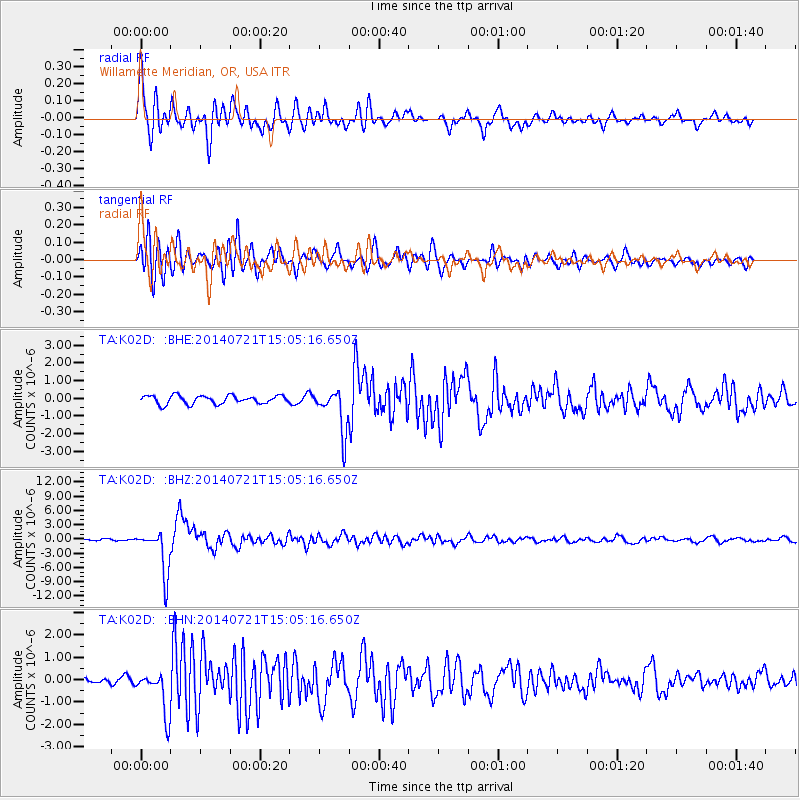
Signal To Noise
| Channel | StoN | STA | LTA |
| TA:K02D: :BHZ:20140721T15:05:16.650Z | 18.583298 | 4.6326145E-6 | 2.4928914E-7 |
| TA:K02D: :BHN:20140721T15:05:16.650Z | 5.161139 | 9.729513E-7 | 1.8851483E-7 |
| TA:K02D: :BHE:20140721T15:05:16.650Z | 5.273738 | 1.2306893E-6 | 2.3336186E-7 |
| Arrivals |
| Ps | 5.2 SECOND |
| PpPs | 15 SECOND |
| PsPs/PpSs | 20 SECOND |


