You are here: Home > Network List > US - United States National Seismic Network Stations List
> Station DGMT Dagmar, Montana, USA > Earthquake Result Viewer
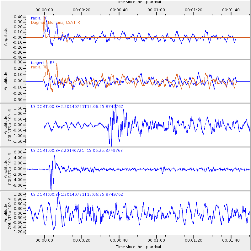
DGMT Dagmar, Montana, USA - Earthquake Result Viewer
*The percent match for this event was below the threshold and hence no stack was calculated.
| Earthquake location: |
Fiji Islands Region |
| Earthquake latitude/longitude: |
-19.8/-178.4 |
| Earthquake time(UTC): |
2014/07/21 (202) 14:54:40 GMT |
| Earthquake Depth: |
616 km |
| Earthquake Magnitude: |
6.9 MWB, 6.9 MI |
| Earthquake Catalog/Contributor: |
NEIC PDE/NEIC ALERT |
|
| Network: |
US United States National Seismic Network |
| Station: |
DGMT Dagmar, Montana, USA |
| Lat/Lon: |
48.47 N/104.20 W |
| Elevation: |
0.0 m |
|
| Distance: |
94.6 deg |
| Az: |
39.987 deg |
| Baz: |
245.413 deg |
| Ray Param: |
$rayparam |
*The percent match for this event was below the threshold and hence was not used in the summary stack. |
|
| Radial Match: |
79.969505 % |
| Radial Bump: |
400 |
| Transverse Match: |
67.535774 % |
| Transverse Bump: |
400 |
| SOD ConfigId: |
751272 |
| Insert Time: |
2014-08-04 15:45:29.655 +0000 |
| GWidth: |
2.5 |
| Max Bumps: |
400 |
| Tol: |
0.001 |
|
Signal To Noise
| Channel | StoN | STA | LTA |
| US:DGMT:00:BHZ:20140721T15:06:25.874976Z | 21.843204 | 2.4395013E-6 | 1.1168239E-7 |
| US:DGMT:00:BH1:20140721T15:06:25.874976Z | 2.2797918 | 5.117321E-7 | 2.2446439E-7 |
| US:DGMT:00:BH2:20140721T15:06:25.874976Z | 1.6088976 | 3.063323E-7 | 1.9039888E-7 |
| Arrivals |
| Ps | |
| PpPs | |
| PsPs/PpSs | |


