You are here: Home > Network List > YN10 - San Jacinto Fault Zone Stations List
> Station JFS2 JFS2 > Earthquake Result Viewer
JFS2 JFS2 - Earthquake Result Viewer
| Earthquake location: |
Fiji Islands Region |
| Earthquake latitude/longitude: |
-19.8/-178.4 |
| Earthquake time(UTC): |
2014/07/21 (202) 14:54:40 GMT |
| Earthquake Depth: |
616 km |
| Earthquake Magnitude: |
6.9 MWB, 6.9 MI |
| Earthquake Catalog/Contributor: |
NEIC PDE/NEIC ALERT |
|
| Network: |
YN San Jacinto Fault Zone |
| Station: |
JFS2 JFS2 |
| Lat/Lon: |
33.42 N/116.40 W |
| Elevation: |
645 m |
|
| Distance: |
79.3 deg |
| Az: |
48.733 deg |
| Baz: |
237.819 deg |
| Ray Param: |
0.047086194 |
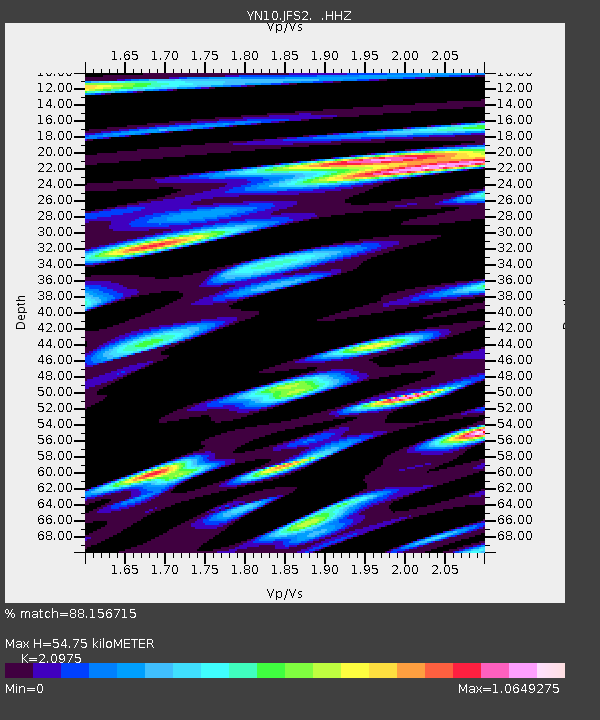
| Estimated Moho Depth: |
54.75 km |
| Estimated Crust Vp/Vs: |
2.10 |
| Assumed Crust Vp: |
6.264 km/s |
| Estimated Crust Vs: |
2.986 km/s |
| Estimated Crust Poisson's Ratio: |
0.35 |
|
| Radial Match: |
88.156715 % |
| Radial Bump: |
400 |
| Transverse Match: |
77.503075 % |
| Transverse Bump: |
400 |
| SOD ConfigId: |
751272 |
| Insert Time: |
2014-08-04 15:53:35.421 +0000 |
| GWidth: |
2.5 |
| Max Bumps: |
400 |
| Tol: |
0.001 |
|

Signal To Noise
| Channel | StoN | STA | LTA |
| YN:JFS2: :HHZ:20140721T15:05:13.103979Z | 67.129974 | 4.705105E-6 | 7.008948E-8 |
| YN:JFS2: :HHN:20140721T15:05:13.103979Z | 6.0733 | 6.769593E-7 | 1.1146482E-7 |
| YN:JFS2: :HHE:20140721T15:05:13.103979Z | 12.768041 | 1.289768E-6 | 1.0101534E-7 |
| Arrivals |
| Ps | 9.8 SECOND |
| PpPs | 27 SECOND |
| PsPs/PpSs | 36 SECOND |


