You are here: Home > Network List > PY - PFO Array Stations List
> Station BPH12 Pinon Flat Observatory, CA, USA > Earthquake Result Viewer
BPH12 Pinon Flat Observatory, CA, USA - Earthquake Result Viewer
| Earthquake location: |
Kuril Islands |
| Earthquake latitude/longitude: |
44.6/148.7 |
| Earthquake time(UTC): |
2014/07/20 (201) 18:32:47 GMT |
| Earthquake Depth: |
61 km |
| Earthquake Magnitude: |
6.6 MB |
| Earthquake Catalog/Contributor: |
NEIC PDE/NEIC COMCAT |
|
| Network: |
PY PFO Array |
| Station: |
BPH12 Pinon Flat Observatory, CA, USA |
| Lat/Lon: |
33.61 N/116.46 W |
| Elevation: |
1251 m |
|
| Distance: |
70.4 deg |
| Az: |
61.989 deg |
| Baz: |
310.941 deg |
| Ray Param: |
0.054885726 |
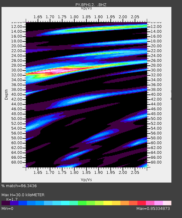
| Estimated Moho Depth: |
30.0 km |
| Estimated Crust Vp/Vs: |
1.70 |
| Assumed Crust Vp: |
6.264 km/s |
| Estimated Crust Vs: |
3.684 km/s |
| Estimated Crust Poisson's Ratio: |
0.24 |
|
| Radial Match: |
96.3436 % |
| Radial Bump: |
348 |
| Transverse Match: |
92.76453 % |
| Transverse Bump: |
400 |
| SOD ConfigId: |
751272 |
| Insert Time: |
2014-08-04 15:57:27.793 +0000 |
| GWidth: |
2.5 |
| Max Bumps: |
400 |
| Tol: |
0.001 |
|

Signal To Noise
| Channel | StoN | STA | LTA |
| PY:BPH12: :BHZ:20140720T18:43:24.249983Z | 21.911139 | 1.5787984E-6 | 7.2054604E-8 |
| PY:BPH12: :BHN:20140720T18:43:24.249983Z | 12.324688 | 4.4162147E-7 | 3.583226E-8 |
| PY:BPH12: :BHE:20140720T18:43:24.249983Z | 9.837417 | 5.5894117E-7 | 5.681788E-8 |
| Arrivals |
| Ps | 3.5 SECOND |
| PpPs | 12 SECOND |
| PsPs/PpSs | 16 SECOND |


