You are here: Home > Network List > TA - USArray Transportable Network (new EarthScope stations) Stations List
> Station I23K Minto, Yukon-Koyukuk, AK, USA > Earthquake Result Viewer
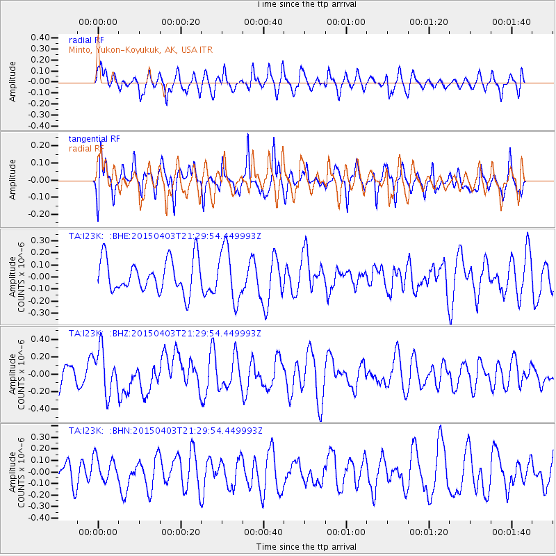
I23K Minto, Yukon-Koyukuk, AK, USA - Earthquake Result Viewer
*The percent match for this event was below the threshold and hence no stack was calculated.
| Earthquake location: |
Eastern New Guinea Reg., P.N.G. |
| Earthquake latitude/longitude: |
-6.3/147.8 |
| Earthquake time(UTC): |
2015/04/03 (093) 21:17:54 GMT |
| Earthquake Depth: |
30 km |
| Earthquake Magnitude: |
5.9 MWW, 5.8 MWB, 5.9 MWC |
| Earthquake Catalog/Contributor: |
NEIC PDE/NEIC COMCAT |
|
| Network: |
TA USArray Transportable Network (new EarthScope stations) |
| Station: |
I23K Minto, Yukon-Koyukuk, AK, USA |
| Lat/Lon: |
65.15 N/149.36 W |
| Elevation: |
149 m |
|
| Distance: |
84.7 deg |
| Az: |
22.197 deg |
| Baz: |
242.705 deg |
| Ray Param: |
$rayparam |
*The percent match for this event was below the threshold and hence was not used in the summary stack. |
|
| Radial Match: |
62.440746 % |
| Radial Bump: |
400 |
| Transverse Match: |
51.563263 % |
| Transverse Bump: |
400 |
| SOD ConfigId: |
7422571 |
| Insert Time: |
2019-04-18 02:16:33.627 +0000 |
| GWidth: |
2.5 |
| Max Bumps: |
400 |
| Tol: |
0.001 |
|
Signal To Noise
| Channel | StoN | STA | LTA |
| TA:I23K: :BHZ:20150403T21:29:54.449993Z | 1.8506707 | 2.5493543E-7 | 1.37753E-7 |
| TA:I23K: :BHN:20150403T21:29:54.449993Z | 0.8150483 | 1.09215804E-7 | 1.3399918E-7 |
| TA:I23K: :BHE:20150403T21:29:54.449993Z | 1.6506093 | 2.2219828E-7 | 1.3461592E-7 |
| Arrivals |
| Ps | |
| PpPs | |
| PsPs/PpSs | |


