You are here: Home > Network List > PE - Penn State Network Stations List
> Station WRPS We R Penn State > Earthquake Result Viewer
WRPS We R Penn State - Earthquake Result Viewer
| Earthquake location: |
Kuril Islands |
| Earthquake latitude/longitude: |
44.6/148.7 |
| Earthquake time(UTC): |
2014/07/20 (201) 18:32:47 GMT |
| Earthquake Depth: |
61 km |
| Earthquake Magnitude: |
6.6 MB |
| Earthquake Catalog/Contributor: |
NEIC PDE/NEIC COMCAT |
|
| Network: |
PE Penn State Network |
| Station: |
WRPS We R Penn State |
| Lat/Lon: |
40.79 N/77.87 W |
| Elevation: |
320 m |
|
| Distance: |
85.2 deg |
| Az: |
33.607 deg |
| Baz: |
328.63 deg |
| Ray Param: |
0.044798054 |
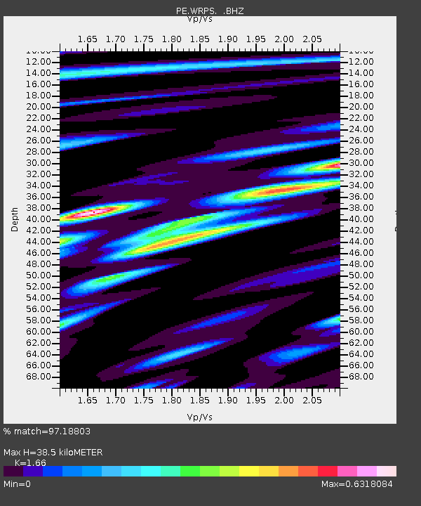
| Estimated Moho Depth: |
38.5 km |
| Estimated Crust Vp/Vs: |
1.66 |
| Assumed Crust Vp: |
6.121 km/s |
| Estimated Crust Vs: |
3.687 km/s |
| Estimated Crust Poisson's Ratio: |
0.22 |
|
| Radial Match: |
97.18803 % |
| Radial Bump: |
229 |
| Transverse Match: |
89.69512 % |
| Transverse Bump: |
383 |
| SOD ConfigId: |
751272 |
| Insert Time: |
2014-08-04 16:00:33.943 +0000 |
| GWidth: |
2.5 |
| Max Bumps: |
400 |
| Tol: |
0.001 |
|
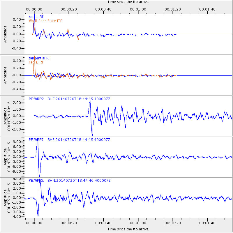
Signal To Noise
| Channel | StoN | STA | LTA |
| PE:WRPS: :BHZ:20140720T18:44:46.400007Z | 52.025845 | 5.800594E-6 | 1.1149447E-7 |
| PE:WRPS: :BHN:20140720T18:44:46.400007Z | 26.528776 | 1.9795634E-6 | 7.461948E-8 |
| PE:WRPS: :BHE:20140720T18:44:46.400007Z | 13.859753 | 1.359221E-6 | 9.806964E-8 |
| Arrivals |
| Ps | 4.2 SECOND |
| PpPs | 16 SECOND |
| PsPs/PpSs | 21 SECOND |


