You are here: Home > Network List > S - Seismographs in Schools Projects Stations List
> Station AUNHS Nhulunbuy High School, NT > Earthquake Result Viewer
AUNHS Nhulunbuy High School, NT - Earthquake Result Viewer
| Earthquake location: |
Kuril Islands |
| Earthquake latitude/longitude: |
44.6/148.7 |
| Earthquake time(UTC): |
2014/07/20 (201) 18:32:47 GMT |
| Earthquake Depth: |
61 km |
| Earthquake Magnitude: |
6.6 MB |
| Earthquake Catalog/Contributor: |
NEIC PDE/NEIC COMCAT |
|
| Network: |
S Seismographs in Schools Projects |
| Station: |
AUNHS Nhulunbuy High School, NT |
| Lat/Lon: |
12.19 S/136.78 E |
| Elevation: |
20 m |
|
| Distance: |
57.6 deg |
| Az: |
193.872 deg |
| Baz: |
10.084 deg |
| Ray Param: |
0.063253656 |
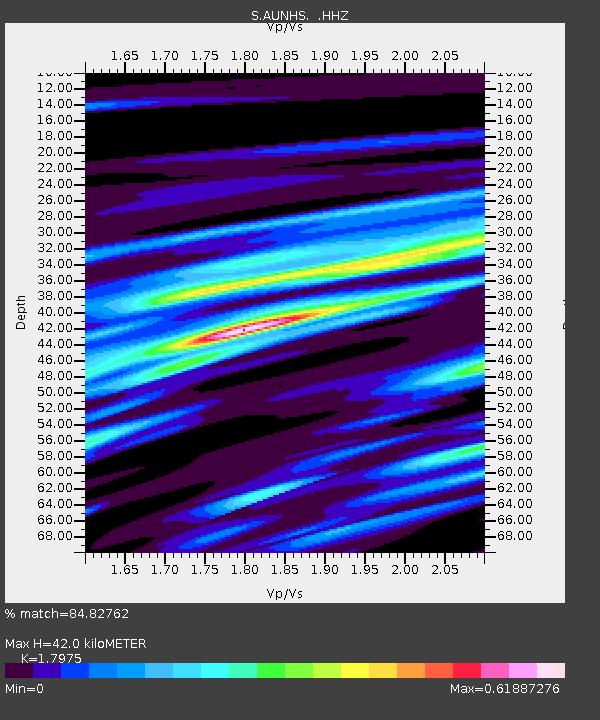
| Estimated Moho Depth: |
42.0 km |
| Estimated Crust Vp/Vs: |
1.80 |
| Assumed Crust Vp: |
6.472 km/s |
| Estimated Crust Vs: |
3.6 km/s |
| Estimated Crust Poisson's Ratio: |
0.28 |
|
| Radial Match: |
84.82762 % |
| Radial Bump: |
400 |
| Transverse Match: |
51.669434 % |
| Transverse Bump: |
400 |
| SOD ConfigId: |
751272 |
| Insert Time: |
2014-08-04 16:04:50.085 +0000 |
| GWidth: |
2.5 |
| Max Bumps: |
400 |
| Tol: |
0.001 |
|

Signal To Noise
| Channel | StoN | STA | LTA |
| S:AUNHS: :HHZ:20140720T18:42:00.369978Z | 3.3582191 | 3.320034E-6 | 9.886294E-7 |
| S:AUNHS: :HHN:20140720T18:42:00.369978Z | 1.5974514 | 1.9976837E-6 | 1.2505443E-6 |
| S:AUNHS: :HHE:20140720T18:42:00.369978Z | 1.2448177 | 8.106921E-7 | 6.512537E-7 |
| Arrivals |
| Ps | 5.4 SECOND |
| PpPs | 17 SECOND |
| PsPs/PpSs | 23 SECOND |


