You are here: Home > Network List > TA - USArray Transportable Network (new EarthScope stations) Stations List
> Station 157A Early Branch, SC, USA > Earthquake Result Viewer
157A Early Branch, SC, USA - Earthquake Result Viewer

| Earthquake location: |
Kuril Islands |
| Earthquake latitude/longitude: |
44.6/148.7 |
| Earthquake time(UTC): |
2014/07/20 (201) 18:32:47 GMT |
| Earthquake Depth: |
61 km |
| Earthquake Magnitude: |
6.6 MB |
| Earthquake Catalog/Contributor: |
NEIC PDE/NEIC COMCAT |
|
| Network: |
TA USArray Transportable Network (new EarthScope stations) |
| Station: |
157A Early Branch, SC, USA |
| Lat/Lon: |
32.68 N/81.00 W |
| Elevation: |
21 m |
|
| Distance: |
90.8 deg |
| Az: |
40.053 deg |
| Baz: |
326.986 deg |
| Ray Param: |
0.04164069 |
| Estimated Moho Depth: |
28.75 km |
| Estimated Crust Vp/Vs: |
2.10 |
| Assumed Crust Vp: |
6.565 km/s |
| Estimated Crust Vs: |
3.13 km/s |
| Estimated Crust Poisson's Ratio: |
0.35 |
|
| Radial Match: |
85.79203 % |
| Radial Bump: |
400 |
| Transverse Match: |
74.015144 % |
| Transverse Bump: |
400 |
| SOD ConfigId: |
751272 |
| Insert Time: |
2014-08-04 16:05:50.116 +0000 |
| GWidth: |
2.5 |
| Max Bumps: |
400 |
| Tol: |
0.001 |
|
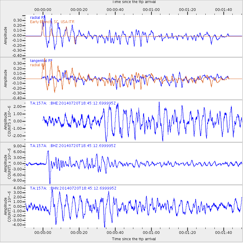
Signal To Noise
| Channel | StoN | STA | LTA |
| TA:157A: :BHZ:20140720T18:45:12.699995Z | 17.623352 | 4.018626E-6 | 2.2802847E-7 |
| TA:157A: :BHN:20140720T18:45:12.699995Z | 2.212009 | 9.768972E-7 | 4.4163352E-7 |
| TA:157A: :BHE:20140720T18:45:12.699995Z | 1.8136395 | 8.205599E-7 | 4.5243823E-7 |
| Arrivals |
| Ps | 4.9 SECOND |
| PpPs | 13 SECOND |
| PsPs/PpSs | 18 SECOND |


