You are here: Home > Network List > TA - USArray Transportable Network (new EarthScope stations) Stations List
> Station C36M Paulatuk, NT, CAN > Earthquake Result Viewer
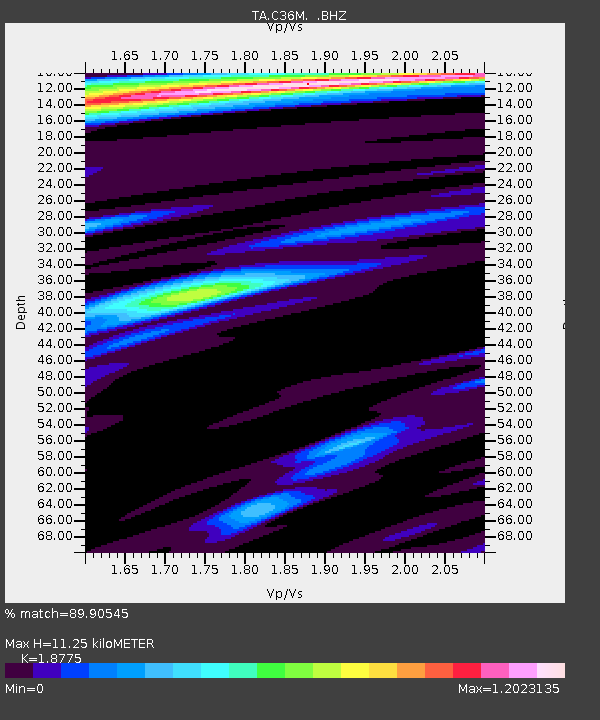
C36M Paulatuk, NT, CAN - Earthquake Result Viewer
| Earthquake location: |
Kuril Islands |
| Earthquake latitude/longitude: |
44.6/148.7 |
| Earthquake time(UTC): |
2014/07/20 (201) 18:32:47 GMT |
| Earthquake Depth: |
61 km |
| Earthquake Magnitude: |
6.6 MB |
| Earthquake Catalog/Contributor: |
NEIC PDE/NEIC COMCAT |
|
| Network: |
TA USArray Transportable Network (new EarthScope stations) |
| Station: |
C36M Paulatuk, NT, CAN |
| Lat/Lon: |
69.35 N/124.07 W |
| Elevation: |
10 m |
|
| Distance: |
48.2 deg |
| Az: |
28.395 deg |
| Baz: |
286.833 deg |
| Ray Param: |
0.06936185 |
| Estimated Moho Depth: |
11.25 km |
| Estimated Crust Vp/Vs: |
1.88 |
| Assumed Crust Vp: |
6.459 km/s |
| Estimated Crust Vs: |
3.44 km/s |
| Estimated Crust Poisson's Ratio: |
0.30 |
|
| Radial Match: |
89.90545 % |
| Radial Bump: |
400 |
| Transverse Match: |
83.30811 % |
| Transverse Bump: |
400 |
| SOD ConfigId: |
751272 |
| Insert Time: |
2014-08-04 16:06:30.194 +0000 |
| GWidth: |
2.5 |
| Max Bumps: |
400 |
| Tol: |
0.001 |
|

Signal To Noise
| Channel | StoN | STA | LTA |
| TA:C36M: :BHZ:20140720T18:40:51.250013Z | 208.87025 | 1.4029272E-5 | 6.71674E-8 |
| TA:C36M: :BHN:20140720T18:40:51.250013Z | 8.145747 | 7.0444906E-7 | 8.64806E-8 |
| TA:C36M: :BHE:20140720T18:40:51.250013Z | 28.897547 | 3.5960588E-6 | 1.2444167E-7 |
| Arrivals |
| Ps | 1.6 SECOND |
| PpPs | 4.7 SECOND |
| PsPs/PpSs | 6.4 SECOND |


