You are here: Home > Network List > TA - USArray Transportable Network (new EarthScope stations) Stations List
> Station D52A ZEK Kipawa Senerzegues Township, QC, CAN > Earthquake Result Viewer
D52A ZEK Kipawa Senerzegues Township, QC, CAN - Earthquake Result Viewer
| Earthquake location: |
Kuril Islands |
| Earthquake latitude/longitude: |
44.6/148.7 |
| Earthquake time(UTC): |
2014/07/20 (201) 18:32:47 GMT |
| Earthquake Depth: |
61 km |
| Earthquake Magnitude: |
6.6 MB |
| Earthquake Catalog/Contributor: |
NEIC PDE/NEIC COMCAT |
|
| Network: |
TA USArray Transportable Network (new EarthScope stations) |
| Station: |
D52A ZEK Kipawa Senerzegues Township, QC, CAN |
| Lat/Lon: |
46.98 N/78.41 W |
| Elevation: |
359 m |
|
| Distance: |
79.8 deg |
| Az: |
30.666 deg |
| Baz: |
327.868 deg |
| Ray Param: |
0.048615936 |
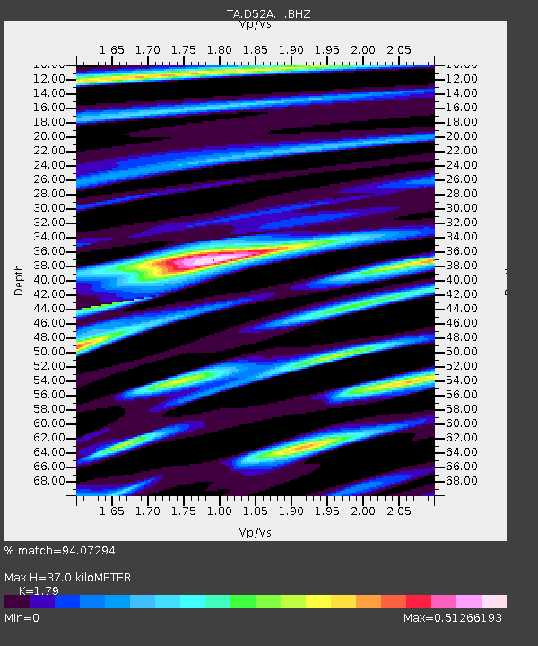
| Estimated Moho Depth: |
37.0 km |
| Estimated Crust Vp/Vs: |
1.79 |
| Assumed Crust Vp: |
6.622 km/s |
| Estimated Crust Vs: |
3.7 km/s |
| Estimated Crust Poisson's Ratio: |
0.27 |
|
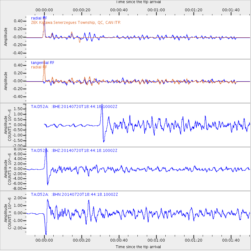
| Radial Match: |
94.07294 % |
| Radial Bump: |
282 |
| Transverse Match: |
83.745895 % |
| Transverse Bump: |
400 |
| SOD ConfigId: |
751272 |
| Insert Time: |
2014-08-04 16:07:09.091 +0000 |
| GWidth: |
2.5 |
| Max Bumps: |
400 |
| Tol: |
0.001 |
|
Signal To Noise
| Channel | StoN | STA | LTA |
| TA:D52A: :BHZ:20140720T18:44:18.10002Z | 32.634567 | 3.7868833E-6 | 1.16039025E-7 |
| TA:D52A: :BHN:20140720T18:44:18.10002Z | 19.422295 | 1.209305E-6 | 6.226376E-8 |
| TA:D52A: :BHE:20140720T18:44:18.10002Z | 12.47102 | 9.560388E-7 | 7.666083E-8 |
| Arrivals |
| Ps | 4.5 SECOND |
| PpPs | 15 SECOND |
| PsPs/PpSs | 20 SECOND |


