You are here: Home > Network List > TA - USArray Transportable Network (new EarthScope stations) Stations List
> Station E57A Chemin Saint Guillaume, Saint Donat, QC, CAN > Earthquake Result Viewer
E57A Chemin Saint Guillaume, Saint Donat, QC, CAN - Earthquake Result Viewer
| Earthquake location: |
Kuril Islands |
| Earthquake latitude/longitude: |
44.6/148.7 |
| Earthquake time(UTC): |
2014/07/20 (201) 18:32:47 GMT |
| Earthquake Depth: |
61 km |
| Earthquake Magnitude: |
6.6 MB |
| Earthquake Catalog/Contributor: |
NEIC PDE/NEIC COMCAT |
|
| Network: |
TA USArray Transportable Network (new EarthScope stations) |
| Station: |
E57A Chemin Saint Guillaume, Saint Donat, QC, CAN |
| Lat/Lon: |
46.41 N/74.15 W |
| Elevation: |
572 m |
|
| Distance: |
81.8 deg |
| Az: |
28.404 deg |
| Baz: |
330.599 deg |
| Ray Param: |
0.047245957 |
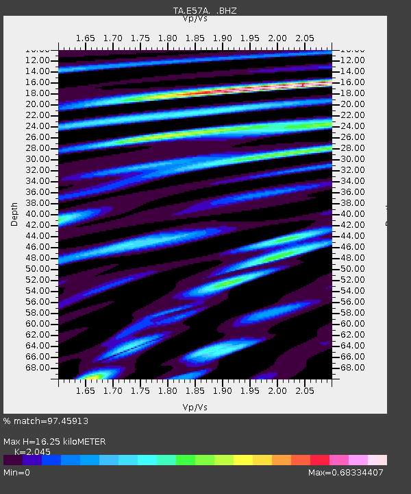
| Estimated Moho Depth: |
16.25 km |
| Estimated Crust Vp/Vs: |
2.05 |
| Assumed Crust Vp: |
6.61 km/s |
| Estimated Crust Vs: |
3.232 km/s |
| Estimated Crust Poisson's Ratio: |
0.34 |
|
| Radial Match: |
97.45913 % |
| Radial Bump: |
347 |
| Transverse Match: |
91.16305 % |
| Transverse Bump: |
400 |
| SOD ConfigId: |
751272 |
| Insert Time: |
2014-08-04 16:08:40.857 +0000 |
| GWidth: |
2.5 |
| Max Bumps: |
400 |
| Tol: |
0.001 |
|
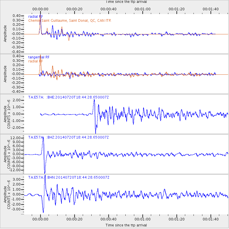
Signal To Noise
| Channel | StoN | STA | LTA |
| TA:E57A: :BHZ:20140720T18:44:28.650007Z | 59.847767 | 6.638735E-6 | 1.1092703E-7 |
| TA:E57A: :BHN:20140720T18:44:28.650007Z | 21.50902 | 1.7632522E-6 | 8.197734E-8 |
| TA:E57A: :BHE:20140720T18:44:28.650007Z | 24.150822 | 1.2640407E-6 | 5.233945E-8 |
| Arrivals |
| Ps | 2.6 SECOND |
| PpPs | 7.3 SECOND |
| PsPs/PpSs | 9.9 SECOND |


