You are here: Home > Network List > TA - USArray Transportable Network (new EarthScope stations) Stations List
> Station E58A La Victoria, QC, CAN > Earthquake Result Viewer
E58A La Victoria, QC, CAN - Earthquake Result Viewer
| Earthquake location: |
Kuril Islands |
| Earthquake latitude/longitude: |
44.6/148.7 |
| Earthquake time(UTC): |
2014/07/20 (201) 18:32:47 GMT |
| Earthquake Depth: |
61 km |
| Earthquake Magnitude: |
6.6 MB |
| Earthquake Catalog/Contributor: |
NEIC PDE/NEIC COMCAT |
|
| Network: |
TA USArray Transportable Network (new EarthScope stations) |
| Station: |
E58A La Victoria, QC, CAN |
| Lat/Lon: |
46.37 N/73.28 W |
| Elevation: |
233 m |
|
| Distance: |
82.1 deg |
| Az: |
27.892 deg |
| Baz: |
331.155 deg |
| Ray Param: |
0.047017902 |
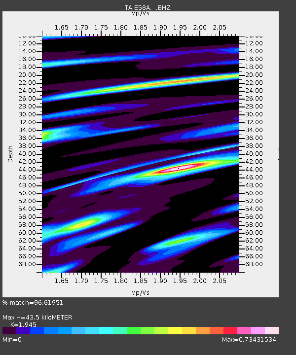
| Estimated Moho Depth: |
43.5 km |
| Estimated Crust Vp/Vs: |
1.95 |
| Assumed Crust Vp: |
6.61 km/s |
| Estimated Crust Vs: |
3.398 km/s |
| Estimated Crust Poisson's Ratio: |
0.32 |
|
| Radial Match: |
96.61951 % |
| Radial Bump: |
335 |
| Transverse Match: |
87.49696 % |
| Transverse Bump: |
400 |
| SOD ConfigId: |
751272 |
| Insert Time: |
2014-08-04 16:08:42.441 +0000 |
| GWidth: |
2.5 |
| Max Bumps: |
400 |
| Tol: |
0.001 |
|

Signal To Noise
| Channel | StoN | STA | LTA |
| TA:E58A: :BHZ:20140720T18:44:30.374983Z | 54.8401 | 6.3119514E-6 | 1.1509737E-7 |
| TA:E58A: :BHN:20140720T18:44:30.374983Z | 15.707067 | 1.8522055E-6 | 1.179218E-7 |
| TA:E58A: :BHE:20140720T18:44:30.374983Z | 10.706958 | 1.2220898E-6 | 1.1413978E-7 |
| Arrivals |
| Ps | 6.4 SECOND |
| PpPs | 19 SECOND |
| PsPs/PpSs | 25 SECOND |


