You are here: Home > Network List > TA - USArray Transportable Network (new EarthScope stations) Stations List
> Station E59A St. Maurice, QC, CAN > Earthquake Result Viewer
E59A St. Maurice, QC, CAN - Earthquake Result Viewer
| Earthquake location: |
Kuril Islands |
| Earthquake latitude/longitude: |
44.6/148.7 |
| Earthquake time(UTC): |
2014/07/20 (201) 18:32:47 GMT |
| Earthquake Depth: |
61 km |
| Earthquake Magnitude: |
6.6 MB |
| Earthquake Catalog/Contributor: |
NEIC PDE/NEIC COMCAT |
|
| Network: |
TA USArray Transportable Network (new EarthScope stations) |
| Station: |
E59A St. Maurice, QC, CAN |
| Lat/Lon: |
46.48 N/72.51 W |
| Elevation: |
62 m |
|
| Distance: |
82.2 deg |
| Az: |
27.37 deg |
| Baz: |
331.637 deg |
| Ray Param: |
0.046908174 |
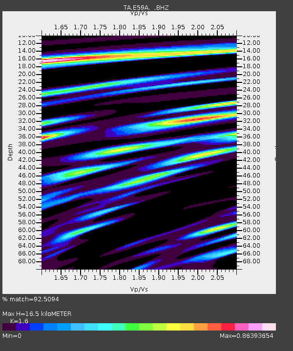
| Estimated Moho Depth: |
16.5 km |
| Estimated Crust Vp/Vs: |
1.60 |
| Assumed Crust Vp: |
6.61 km/s |
| Estimated Crust Vs: |
4.131 km/s |
| Estimated Crust Poisson's Ratio: |
0.18 |
|
| Radial Match: |
92.5094 % |
| Radial Bump: |
400 |
| Transverse Match: |
78.326904 % |
| Transverse Bump: |
400 |
| SOD ConfigId: |
751272 |
| Insert Time: |
2014-08-04 16:08:49.035 +0000 |
| GWidth: |
2.5 |
| Max Bumps: |
400 |
| Tol: |
0.001 |
|
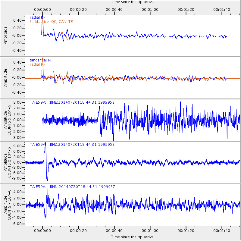
Signal To Noise
| Channel | StoN | STA | LTA |
| TA:E59A: :BHZ:20140720T18:44:31.199995Z | 13.232821 | 5.1553347E-6 | 3.8958697E-7 |
| TA:E59A: :BHN:20140720T18:44:31.199995Z | 5.0108786 | 2.0768673E-6 | 4.1447169E-7 |
| TA:E59A: :BHE:20140720T18:44:31.199995Z | 2.614914 | 1.1636397E-6 | 4.4500115E-7 |
| Arrivals |
| Ps | 1.5 SECOND |
| PpPs | 6.3 SECOND |
| PsPs/PpSs | 7.8 SECOND |


