You are here: Home > Network List > TA - USArray Transportable Network (new EarthScope stations) Stations List
> Station F49A Sandfield, ON, CAN > Earthquake Result Viewer
F49A Sandfield, ON, CAN - Earthquake Result Viewer
| Earthquake location: |
Kuril Islands |
| Earthquake latitude/longitude: |
44.6/148.7 |
| Earthquake time(UTC): |
2014/07/20 (201) 18:32:47 GMT |
| Earthquake Depth: |
61 km |
| Earthquake Magnitude: |
6.6 MB |
| Earthquake Catalog/Contributor: |
NEIC PDE/NEIC COMCAT |
|
| Network: |
TA USArray Transportable Network (new EarthScope stations) |
| Station: |
F49A Sandfield, ON, CAN |
| Lat/Lon: |
45.76 N/82.04 W |
| Elevation: |
230 m |
|
| Distance: |
79.4 deg |
| Az: |
33.481 deg |
| Baz: |
325.756 deg |
| Ray Param: |
0.048862107 |
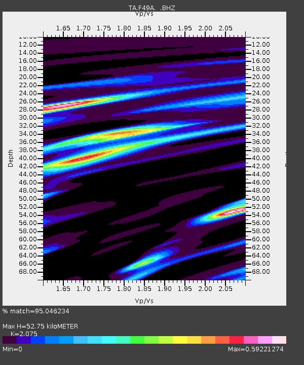
| Estimated Moho Depth: |
52.75 km |
| Estimated Crust Vp/Vs: |
2.08 |
| Assumed Crust Vp: |
6.483 km/s |
| Estimated Crust Vs: |
3.124 km/s |
| Estimated Crust Poisson's Ratio: |
0.35 |
|
| Radial Match: |
95.046234 % |
| Radial Bump: |
270 |
| Transverse Match: |
82.08309 % |
| Transverse Bump: |
400 |
| SOD ConfigId: |
751272 |
| Insert Time: |
2014-08-04 16:09:31.864 +0000 |
| GWidth: |
2.5 |
| Max Bumps: |
400 |
| Tol: |
0.001 |
|
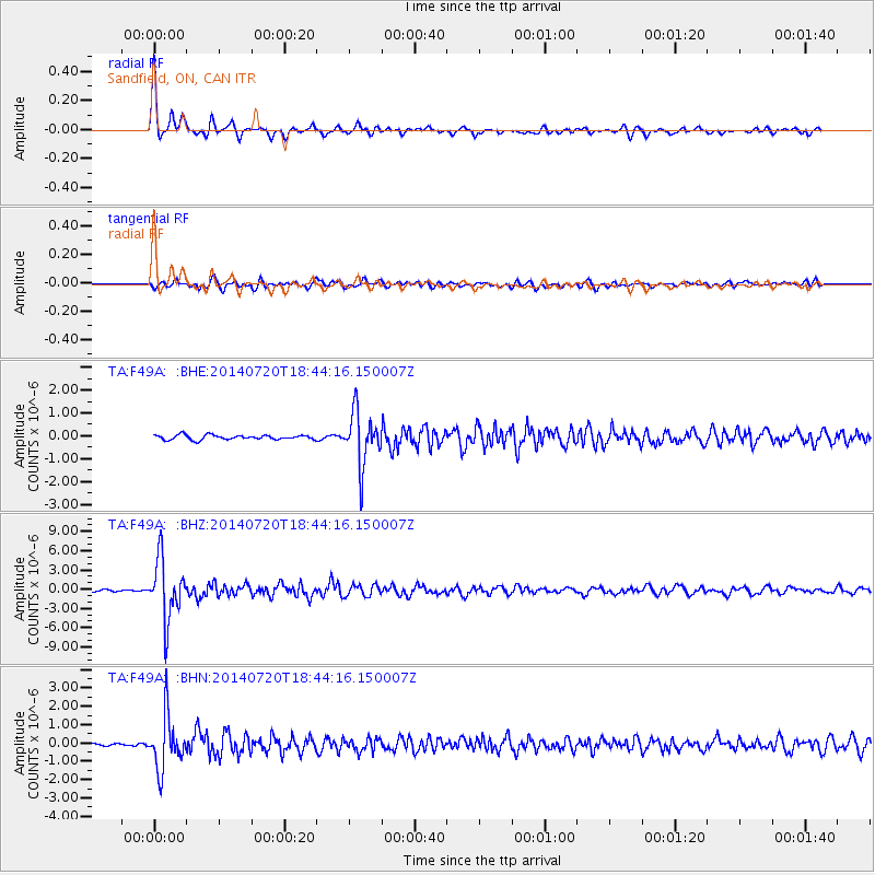
Signal To Noise
| Channel | StoN | STA | LTA |
| TA:F49A: :BHZ:20140720T18:44:16.150007Z | 34.505703 | 4.567771E-6 | 1.3237728E-7 |
| TA:F49A: :BHN:20140720T18:44:16.150007Z | 16.479836 | 1.4122742E-6 | 8.56971E-8 |
| TA:F49A: :BHE:20140720T18:44:16.150007Z | 11.419065 | 1.1492966E-6 | 1.0064717E-7 |
| Arrivals |
| Ps | 9.0 SECOND |
| PpPs | 24 SECOND |
| PsPs/PpSs | 33 SECOND |


