You are here: Home > Network List > TA - USArray Transportable Network (new EarthScope stations) Stations List
> Station F60A Warwick, QC, CAN > Earthquake Result Viewer
F60A Warwick, QC, CAN - Earthquake Result Viewer
| Earthquake location: |
Kuril Islands |
| Earthquake latitude/longitude: |
44.6/148.7 |
| Earthquake time(UTC): |
2014/07/20 (201) 18:32:47 GMT |
| Earthquake Depth: |
61 km |
| Earthquake Magnitude: |
6.6 MB |
| Earthquake Catalog/Contributor: |
NEIC PDE/NEIC COMCAT |
|
| Network: |
TA USArray Transportable Network (new EarthScope stations) |
| Station: |
F60A Warwick, QC, CAN |
| Lat/Lon: |
45.97 N/71.95 W |
| Elevation: |
229 m |
|
| Distance: |
82.9 deg |
| Az: |
27.268 deg |
| Baz: |
332.026 deg |
| Ray Param: |
0.046468653 |
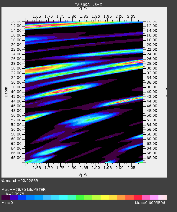
| Estimated Moho Depth: |
26.75 km |
| Estimated Crust Vp/Vs: |
2.10 |
| Assumed Crust Vp: |
6.419 km/s |
| Estimated Crust Vs: |
3.06 km/s |
| Estimated Crust Poisson's Ratio: |
0.35 |
|
| Radial Match: |
90.22869 % |
| Radial Bump: |
400 |
| Transverse Match: |
78.85757 % |
| Transverse Bump: |
400 |
| SOD ConfigId: |
751272 |
| Insert Time: |
2014-08-04 16:09:52.469 +0000 |
| GWidth: |
2.5 |
| Max Bumps: |
400 |
| Tol: |
0.001 |
|
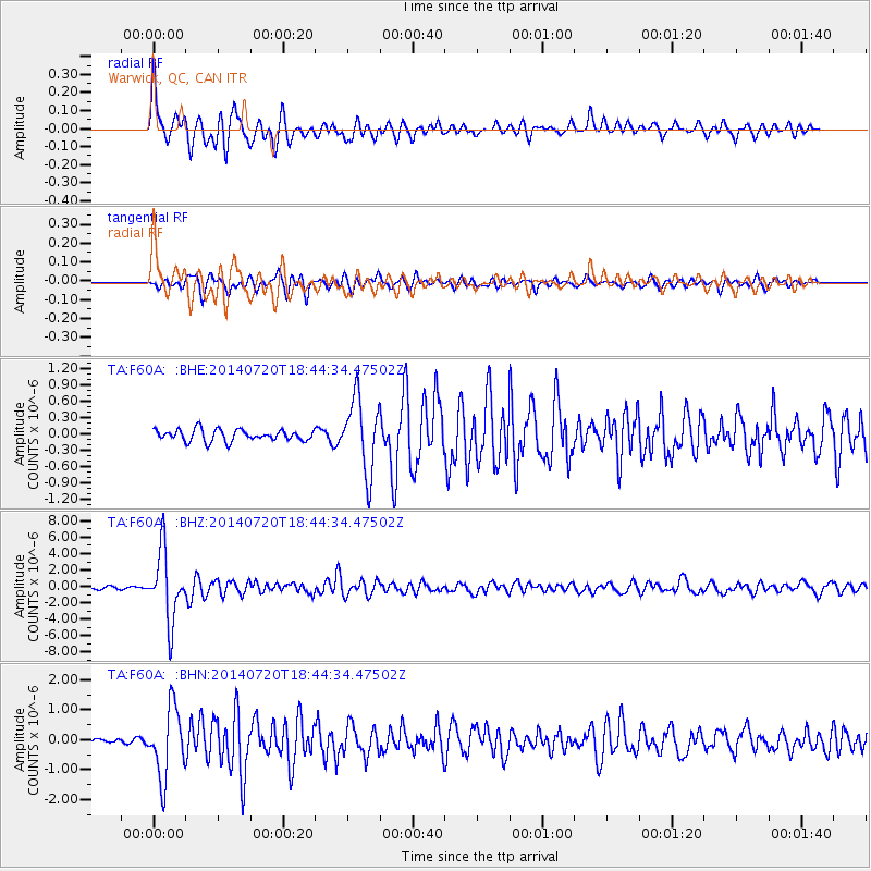
Signal To Noise
| Channel | StoN | STA | LTA |
| TA:F60A: :BHZ:20140720T18:44:34.47502Z | 30.343508 | 4.2156535E-6 | 1.3893097E-7 |
| TA:F60A: :BHN:20140720T18:44:34.47502Z | 9.251744 | 1.1538997E-6 | 1.2472239E-7 |
| TA:F60A: :BHE:20140720T18:44:34.47502Z | 6.3280764 | 6.6960365E-7 | 1.0581473E-7 |
| Arrivals |
| Ps | 4.7 SECOND |
| PpPs | 13 SECOND |
| PsPs/PpSs | 17 SECOND |


