You are here: Home > Network List > TA - USArray Transportable Network (new EarthScope stations) Stations List
> Station G59A Clarenceville, QC, USA > Earthquake Result Viewer
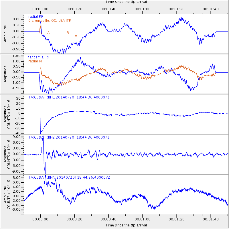
G59A Clarenceville, QC, USA - Earthquake Result Viewer
*The percent match for this event was below the threshold and hence no stack was calculated.
| Earthquake location: |
Kuril Islands |
| Earthquake latitude/longitude: |
44.6/148.7 |
| Earthquake time(UTC): |
2014/07/20 (201) 18:32:47 GMT |
| Earthquake Depth: |
61 km |
| Earthquake Magnitude: |
6.6 MB |
| Earthquake Catalog/Contributor: |
NEIC PDE/NEIC COMCAT |
|
| Network: |
TA USArray Transportable Network (new EarthScope stations) |
| Station: |
G59A Clarenceville, QC, USA |
| Lat/Lon: |
45.08 N/73.18 W |
| Elevation: |
36 m |
|
| Distance: |
83.2 deg |
| Az: |
28.459 deg |
| Baz: |
331.296 deg |
| Ray Param: |
$rayparam |
*The percent match for this event was below the threshold and hence was not used in the summary stack. |
|
| Radial Match: |
19.831594 % |
| Radial Bump: |
400 |
| Transverse Match: |
17.526894 % |
| Transverse Bump: |
400 |
| SOD ConfigId: |
751272 |
| Insert Time: |
2014-08-04 16:10:40.437 +0000 |
| GWidth: |
2.5 |
| Max Bumps: |
400 |
| Tol: |
0.001 |
|
Signal To Noise
| Channel | StoN | STA | LTA |
| TA:G59A: :BHZ:20140720T18:44:36.400007Z | 31.14111 | 4.8287884E-6 | 1.5506154E-7 |
| TA:G59A: :BHN:20140720T18:44:36.400007Z | 2.1578813 | 1.36243125E-5 | 6.3137454E-6 |
| TA:G59A: :BHE:20140720T18:44:36.400007Z | 0.6334495 | 7.809579E-6 | 1.2328654E-5 |
| Arrivals |
| Ps | |
| PpPs | |
| PsPs/PpSs | |


