You are here: Home > Network List > TA - USArray Transportable Network (new EarthScope stations) Stations List
> Station G61A St-Isidore-de-Clifton, QC, USA > Earthquake Result Viewer
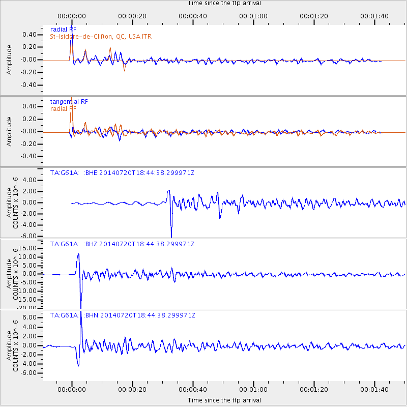
G61A St-Isidore-de-Clifton, QC, USA - Earthquake Result Viewer
| Earthquake location: |
Kuril Islands |
| Earthquake latitude/longitude: |
44.6/148.7 |
| Earthquake time(UTC): |
2014/07/20 (201) 18:32:47 GMT |
| Earthquake Depth: |
61 km |
| Earthquake Magnitude: |
6.6 MB |
| Earthquake Catalog/Contributor: |
NEIC PDE/NEIC COMCAT |
|
| Network: |
TA USArray Transportable Network (new EarthScope stations) |
| Station: |
G61A St-Isidore-de-Clifton, QC, USA |
| Lat/Lon: |
45.28 N/71.53 W |
| Elevation: |
378 m |
|
| Distance: |
83.6 deg |
| Az: |
27.326 deg |
| Baz: |
332.335 deg |
| Ray Param: |
0.045941647 |
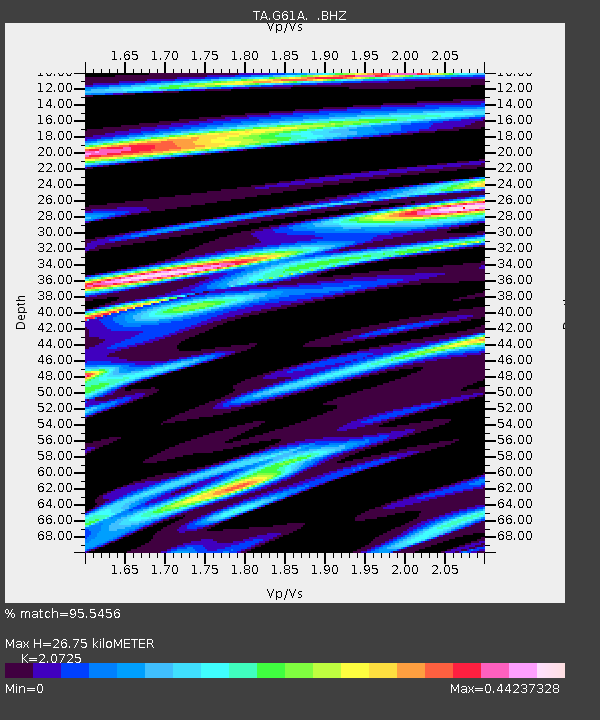
| Estimated Moho Depth: |
26.75 km |
| Estimated Crust Vp/Vs: |
2.07 |
| Assumed Crust Vp: |
6.419 km/s |
| Estimated Crust Vs: |
3.097 km/s |
| Estimated Crust Poisson's Ratio: |
0.35 |
|
| Radial Match: |
95.5456 % |
| Radial Bump: |
337 |
| Transverse Match: |
88.99843 % |
| Transverse Bump: |
398 |
| SOD ConfigId: |
751272 |
| Insert Time: |
2014-08-04 16:10:48.174 +0000 |
| GWidth: |
2.5 |
| Max Bumps: |
400 |
| Tol: |
0.001 |
|
Signal To Noise
| Channel | StoN | STA | LTA |
| TA:G61A: :BHZ:20140720T18:44:38.299971Z | 46.20565 | 6.8361705E-6 | 1.4795097E-7 |
| TA:G61A: :BHN:20140720T18:44:38.299971Z | 18.452892 | 2.515836E-6 | 1.363383E-7 |
| TA:G61A: :BHE:20140720T18:44:38.299971Z | 12.163042 | 1.7455937E-6 | 1.4351622E-7 |
| Arrivals |
| Ps | 4.6 SECOND |
| PpPs | 13 SECOND |
| PsPs/PpSs | 17 SECOND |


