You are here: Home > Network List > TA - USArray Transportable Network (new EarthScope stations) Stations List
> Station G64A Maxfield, ME, USA > Earthquake Result Viewer
G64A Maxfield, ME, USA - Earthquake Result Viewer
| Earthquake location: |
Kuril Islands |
| Earthquake latitude/longitude: |
44.6/148.7 |
| Earthquake time(UTC): |
2014/07/20 (201) 18:32:47 GMT |
| Earthquake Depth: |
61 km |
| Earthquake Magnitude: |
6.6 MB |
| Earthquake Catalog/Contributor: |
NEIC PDE/NEIC COMCAT |
|
| Network: |
TA USArray Transportable Network (new EarthScope stations) |
| Station: |
G64A Maxfield, ME, USA |
| Lat/Lon: |
45.25 N/68.76 W |
| Elevation: |
165 m |
|
| Distance: |
84.5 deg |
| Az: |
25.583 deg |
| Baz: |
334.118 deg |
| Ray Param: |
0.04530198 |
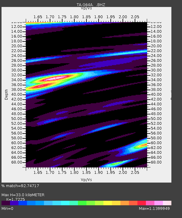
| Estimated Moho Depth: |
33.0 km |
| Estimated Crust Vp/Vs: |
1.72 |
| Assumed Crust Vp: |
6.419 km/s |
| Estimated Crust Vs: |
3.727 km/s |
| Estimated Crust Poisson's Ratio: |
0.25 |
|
| Radial Match: |
92.74717 % |
| Radial Bump: |
388 |
| Transverse Match: |
88.972664 % |
| Transverse Bump: |
400 |
| SOD ConfigId: |
751272 |
| Insert Time: |
2014-08-04 16:11:24.553 +0000 |
| GWidth: |
2.5 |
| Max Bumps: |
400 |
| Tol: |
0.001 |
|

Signal To Noise
| Channel | StoN | STA | LTA |
| TA:G64A: :BHZ:20140720T18:44:42.900007Z | 56.060295 | 5.1849993E-6 | 9.248969E-8 |
| TA:G64A: :BHN:20140720T18:44:42.900007Z | 11.224982 | 1.5542184E-6 | 1.3846066E-7 |
| TA:G64A: :BHE:20140720T18:44:42.900007Z | 6.902615 | 9.0794373E-7 | 1.315362E-7 |
| Arrivals |
| Ps | 3.8 SECOND |
| PpPs | 14 SECOND |
| PsPs/PpSs | 17 SECOND |


